IMAGES TAKEN NEAR TO
Seaton Ross, YORK, YO42 4NA
Introduction
This page details the photographs taken nearby to YO42 4NA by members of the Geograph project.
The Geograph project started in 2005 with the aim of publishing, organising and preserving representative images for every square kilometre of Great Britain, Ireland and the Isle of Man.

There are currently over 7.5m images from over14,400 individuals and you can help contribute to the project by visiting https://www.geograph.org.uk
Image Map (Loading...)


Getting Data...Please wait
Leaflet Map data © OpenStreetMap
Images are licensed for reuse under creativecommons.org/licenses/by-sa/2.0
Notes
- Clicking on the map will re-center to the selected point.
- The higher the marker number, the further away the image location is from the centre of the postcode.
Image Listing (15 Images Found)
Images are licensed for reuse under creativecommons.org/licenses/by-sa/2.0
Image
Details
Distance
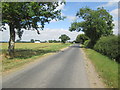
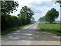
1
Passing place on Southfield Lane
Looking along the road to Seaton Ross.
Image: © DS Pugh
Taken: 22 Apr 2017
0.03 miles
2
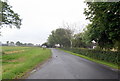
Entering Seaton Ross on Southfield Lane
Image: © David Brown
Taken: 19 Jun 2020
0.04 miles
3
Southfield Lane toward Seaton Ross
The village name sign is on the left beyond the passing place
Image: © Martin Dawes
Taken: 4 Jul 2018
0.04 miles
4
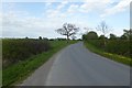
Road to Seaton Ross
Looking along Southfield Lane.
Image: © DS Pugh
Taken: 22 Apr 2017
0.07 miles
5
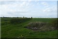
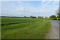
Farmland near Wood Dike
Looking north from Southfield Lane.
Image: © DS Pugh
Taken: 22 Apr 2017
0.09 miles
6
Southfield Lane toward Green Farm
Green Farm can be seen on the right
Image: © Martin Dawes
Taken: 4 Jul 2018
0.13 miles
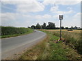
8

Approaching Rose Farm
The sign advertises a pop up pub.
Image: © DS Pugh
Taken: 22 Apr 2017
0.21 miles
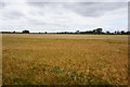
10
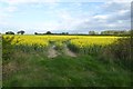
Rape off Southfield Lane
Looking over oil seed rape fields in full flower.
Image: © DS Pugh
Taken: 22 Apr 2017
0.23 miles