IMAGES TAKEN NEAR TO
Miller Close, Southfield Road, YORK, YO42 2XZ
Introduction
This page details the photographs taken nearby to Miller Close, Southfield Road, YO42 2XZ by members of the Geograph project.
The Geograph project started in 2005 with the aim of publishing, organising and preserving representative images for every square kilometre of Great Britain, Ireland and the Isle of Man.

There are currently over 7.5m images from over14,400 individuals and you can help contribute to the project by visiting https://www.geograph.org.uk
Image Map (Loading...)


Getting Data...Please wait
Leaflet Map data © OpenStreetMap
Images are licensed for reuse under creativecommons.org/licenses/by-sa/2.0
Notes
- Clicking on the map will re-center to the selected point.
- The higher the marker number, the further away the image location is from the centre of the postcode.
Image Listing (7 Images Found)
Images are licensed for reuse under creativecommons.org/licenses/by-sa/2.0
Image
Details
Distance
1

Pocklington Airfield
This is the view from the northern end of Pocklington Airfield. This was the site of a World War II bomber base. It is now an industrial estate, gliding school and farmland. This is the view looking southwards from MR: SE79264909.
Image: © Andy Beecroft
Taken: 18 Jan 2006
0.12 miles
2
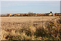
New housing in Pocklington
This view across the wheatfields is seen from the layby on Barmby Road.
Image: © Peter Church
Taken: 19 Nov 2008
0.15 miles
3
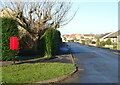
Sherbuttgate Road North, Pocklington
Showing position of Postbox No. YO42 376.
See Image] for postbox.
Image: © JThomas
Taken: 16 Dec 2021
0.18 miles
4
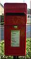
Elizabeth II postbox on Sherbuttgate Road North, Pocklington
Image: © JThomas
Taken: 16 Dec 2021
0.19 miles
5
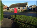
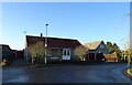
Bungalows on Sherbuttgate Road North, Pocklington
Showing position of Postbox No. YO42 376.
See Image] for postbox.
Image: © JThomas
Taken: 16 Dec 2021
0.20 miles
6
Bungalow on Sherbuttgate Road North, Pocklington
Image: © JThomas
Taken: 16 Dec 2021
0.20 miles
7
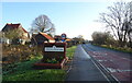
Entering Pocklington
On Barmby Road (B1246).
Image: © JThomas
Taken: 16 Dec 2021
0.22 miles