IMAGES TAKEN NEAR TO
Symons Way, YORK, YO42 2XT
Introduction
This page details the photographs taken nearby to Symons Way, YO42 2XT by members of the Geograph project.
The Geograph project started in 2005 with the aim of publishing, organising and preserving representative images for every square kilometre of Great Britain, Ireland and the Isle of Man.

There are currently over 7.5m images from over14,400 individuals and you can help contribute to the project by visiting https://www.geograph.org.uk
Image Map (145 Images)


Getting Data...Please wait
Leaflet Map data © OpenStreetMap
Images are licensed for reuse under creativecommons.org/licenses/by-sa/2.0
Notes
- Clicking on the map will re-center to the selected point.
- The higher the marker number, the further away the image location is from the centre of the postcode.
Image Listing (145 Images Found)
Images are licensed for reuse under creativecommons.org/licenses/by-sa/2.0
Image
Details
Distance


4

A mini walk around Pocklington #10
Cemetery Lane.
Image: © Ian S
Taken: 9 Aug 2010
0.03 miles

6
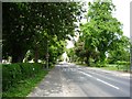
West Green
Approaching Pocklington school on West Green, Pocklington.
Image: © DS Pugh
Taken: 25 May 2009
0.04 miles
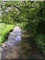
7

A mini walk around Pocklington #8
Thirsk Bridge
Image: © Ian S
Taken: 9 Aug 2010
0.04 miles
8
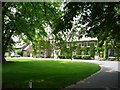
Pocklington School
Pocklington School on West Green in Pocklington.
Image: © DS Pugh
Taken: 25 May 2009
0.06 miles
9
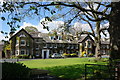
Pocklington School on West Green, Pocklington
Image: © Ian S
Taken: 29 Apr 2015
0.06 miles
10
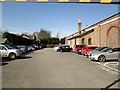
Car park behind the old station
This on the dismantled Beverley to York line
Image: © Martin Dawes
Taken: 15 Mar 2017
0.07 miles