IMAGES TAKEN NEAR TO
Southfield Close, YORK, YO42 2XQ
Introduction
This page details the photographs taken nearby to Southfield Close, YO42 2XQ by members of the Geograph project.
The Geograph project started in 2005 with the aim of publishing, organising and preserving representative images for every square kilometre of Great Britain, Ireland and the Isle of Man.

There are currently over 7.5m images from over14,400 individuals and you can help contribute to the project by visiting https://www.geograph.org.uk
Image Map (Loading...)


Getting Data...Please wait
Leaflet Map data © OpenStreetMap
Images are licensed for reuse under creativecommons.org/licenses/by-sa/2.0
Notes
- Clicking on the map will re-center to the selected point.
- The higher the marker number, the further away the image location is from the centre of the postcode.
Image Listing (25 Images Found)
Images are licensed for reuse under creativecommons.org/licenses/by-sa/2.0
Image
Details
Distance
1
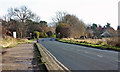
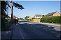
Entering Pocklington from the west
This image is on Barmby Road, the B1246.
Image: © Peter Church
Taken: 19 Nov 2008
0.02 miles
4
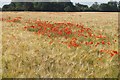
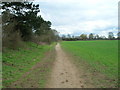
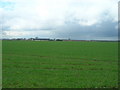
Poppies in Wheat Field off Barmby Road, Pockington
Image: © Ian S
Taken: 24 Jun 2020
0.09 miles
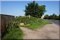
6
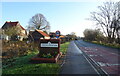
Entering Pocklington
On Barmby Road (B1246).
Image: © JThomas
Taken: 16 Dec 2021
0.10 miles
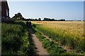
10
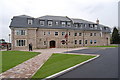
Pocklington School new Boarding House
The Fenwick Smith House
Image: © Malcolm Sandilands
Taken: 20 Apr 2007
0.13 miles