IMAGES TAKEN NEAR TO
Wheatley Drive, YORK, YO42 2TU
Introduction
This page details the photographs taken nearby to Wheatley Drive, YO42 2TU by members of the Geograph project.
The Geograph project started in 2005 with the aim of publishing, organising and preserving representative images for every square kilometre of Great Britain, Ireland and the Isle of Man.

There are currently over 7.5m images from over14,400 individuals and you can help contribute to the project by visiting https://www.geograph.org.uk
Image Map (Loading...)


Getting Data...Please wait
Leaflet Map data © OpenStreetMap
Images are licensed for reuse under creativecommons.org/licenses/by-sa/2.0
Notes
- Clicking on the map will re-center to the selected point.
- The higher the marker number, the further away the image location is from the centre of the postcode.
Image Listing (15 Images Found)
Images are licensed for reuse under creativecommons.org/licenses/by-sa/2.0
Image
Details
Distance
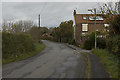
2
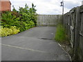
Pumping Station Entrance off Nicholson Court
Image: © Darren Haddock
Taken: 14 Jun 2013
0.10 miles
3
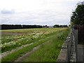
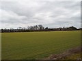
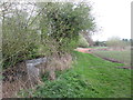
Field path by Devonshire Mill, S of Pocklington
Image: © Colin Park
Taken: 14 May 2017
0.11 miles
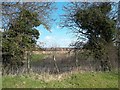
5
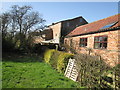
Devonshire Mill on Pocklington Beck
The single storey buildings on the right look like holiday lets
Image: © Martin Dawes
Taken: 15 Mar 2017
0.13 miles

8
Canal Lane, Pocklington
This lane must have once served an important role as a route into the town for goods transported by canal.
Image: © Paul Harrop
Taken: 4 Nov 2009
0.21 miles
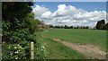
10
Footpath towards Pocklington, south of Devonshire Mill
Image: © John Slater
Taken: 12 Apr 2014
0.22 miles