IMAGES TAKEN NEAR TO
Clayfield Road, YORK, YO42 2RG
Introduction
This page details the photographs taken nearby to Clayfield Road, YO42 2RG by members of the Geograph project.
The Geograph project started in 2005 with the aim of publishing, organising and preserving representative images for every square kilometre of Great Britain, Ireland and the Isle of Man.

There are currently over 7.5m images from over14,400 individuals and you can help contribute to the project by visiting https://www.geograph.org.uk
Image Map (Loading...)


Getting Data...Please wait
Leaflet Map data © OpenStreetMap
Images are licensed for reuse under creativecommons.org/licenses/by-sa/2.0
Notes
- Clicking on the map will re-center to the selected point.
- The higher the marker number, the further away the image location is from the centre of the postcode.
Image Listing (38 Images Found)
Images are licensed for reuse under creativecommons.org/licenses/by-sa/2.0
Image
Details
Distance
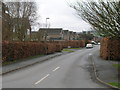
2
Burnby Lane
Entering Pocklington along Burnby Lane.
Image: © DS Pugh
Taken: 29 Sep 2013
0.12 miles
3
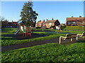
Children's playground, The Oval, Pocklington
Image: © JThomas
Taken: 16 Dec 2021
0.12 miles
4
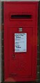
George VI postbox on the Oval, Pocklington
Image: © JThomas
Taken: 16 Dec 2021
0.14 miles
5
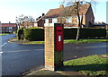
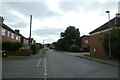
Houses on the Oval, Pocklington
Showing position of Postbox No. YO42 457.
See Image] for postbox.
Image: © JThomas
Taken: 16 Dec 2021
0.15 miles
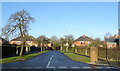
7
The Oval, Pocklington
Showing position of Postbox No. YO42 457.
See Image] for postbox.
Image: © JThomas
Taken: 16 Dec 2021
0.15 miles
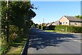
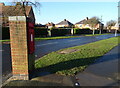
9
Percy Road
Looking along Percy Road at the junction of The Oval.
Image: © DS Pugh
Taken: 4 Jun 2022
0.18 miles