IMAGES TAKEN NEAR TO
The Balk, YORK, YO42 2NY
Introduction
This page details the photographs taken nearby to The Balk, YO42 2NY by members of the Geograph project.
The Geograph project started in 2005 with the aim of publishing, organising and preserving representative images for every square kilometre of Great Britain, Ireland and the Isle of Man.

There are currently over 7.5m images from over14,400 individuals and you can help contribute to the project by visiting https://www.geograph.org.uk
Image Map (Loading...)


Getting Data...Please wait
Leaflet Map data © OpenStreetMap
Images are licensed for reuse under creativecommons.org/licenses/by-sa/2.0
Notes
- Clicking on the map will re-center to the selected point.
- The higher the marker number, the further away the image location is from the centre of the postcode.
Image Listing (6 Images Found)
Images are licensed for reuse under creativecommons.org/licenses/by-sa/2.0
Image
Details
Distance
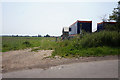
3
A house in a middle of a field
Near Pocklington, East Yorkshire.
Image: © Ian S
Taken: 31 Jul 2010
0.16 miles
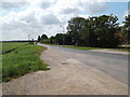
4
Footpath near Duck Belt
This is a short footpath which leads to the B1247 (Pocklington to Market Weighton Road). This picture and its foreground are within the allotted square.
Image: © Andy Beecroft
Taken: 11 Sep 2006
0.18 miles
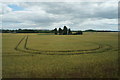
5
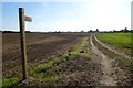
Footpath to the B1247
Running from Burnby Lane.
Image: © DS Pugh
Taken: 29 Sep 2013
0.22 miles