IMAGES TAKEN NEAR TO
West Green, YORK, YO42 2NL
Introduction
This page details the photographs taken nearby to West Green, YO42 2NL by members of the Geograph project.
The Geograph project started in 2005 with the aim of publishing, organising and preserving representative images for every square kilometre of Great Britain, Ireland and the Isle of Man.

There are currently over 7.5m images from over14,400 individuals and you can help contribute to the project by visiting https://www.geograph.org.uk
Image Map (Loading...)


Getting Data...Please wait
Leaflet Map data © OpenStreetMap
Images are licensed for reuse under creativecommons.org/licenses/by-sa/2.0
Notes
- Clicking on the map will re-center to the selected point.
- The higher the marker number, the further away the image location is from the centre of the postcode.
Image Listing (23 Images Found)
Images are licensed for reuse under creativecommons.org/licenses/by-sa/2.0
Image
Details
Distance
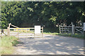
1
New farm buildings off Hodsow Lane, Pocklington
Image: © Ian S
Taken: 24 Jun 2020
0.07 miles
2
Pocklington Glider Club not open to Visitors
Due to the Coronavirus outbreak.
Image: © Ian S
Taken: 24 Jun 2020
0.08 miles
3
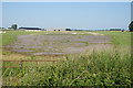
Disused airstrip at Pocklington Airfield
The grass airstrip (31) is to right of the disused strip.
Image: © Ian S
Taken: 24 Jun 2020
0.10 miles
4
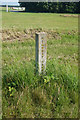
Highway Boundary Marker on Hodsow Lane, Pocklington
Image: © Ian S
Taken: 24 Jun 2020
0.11 miles
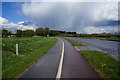
6
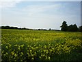
Field of rape near Pocklington airfield
Some of the buildings on the airfield now used by gliders can be seen over the oilseed rape.
Image: © DS Pugh
Taken: 25 May 2009
0.13 miles