IMAGES TAKEN NEAR TO
Kilnwick Road, YORK, YO42 2JZ
Introduction
This page details the photographs taken nearby to Kilnwick Road, YO42 2JZ by members of the Geograph project.
The Geograph project started in 2005 with the aim of publishing, organising and preserving representative images for every square kilometre of Great Britain, Ireland and the Isle of Man.

There are currently over 7.5m images from over14,400 individuals and you can help contribute to the project by visiting https://www.geograph.org.uk
Image Map
Images are licensed for reuse under creativecommons.org/licenses/by-sa/2.0
Notes
- Clicking on the map will re-center to the selected point.
- The higher the marker number, the further away the image location is from the centre of the postcode.
Image Listing (69 Images Found)
Images are licensed for reuse under creativecommons.org/licenses/by-sa/2.0
Image
Details
Distance
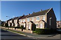
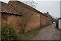
4
Clock Mill Lane, Pocklington
The Chalkland Way footpath passes by this quaintly-named lane, off the B1246 road into Pocklington.
Image: © Dr Patty McAlpin
Taken: 26 Jul 2009
0.06 miles
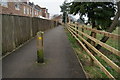
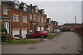
5
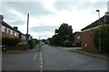
Percy Road
Looking along Percy Road at the junction of The Oval.
Image: © DS Pugh
Taken: 4 Jun 2022
0.06 miles