IMAGES TAKEN NEAR TO
Pavement, YORK, YO42 2AX
Introduction
This page details the photographs taken nearby to Pavement, YO42 2AX by members of the Geograph project.
The Geograph project started in 2005 with the aim of publishing, organising and preserving representative images for every square kilometre of Great Britain, Ireland and the Isle of Man.

There are currently over 7.5m images from over14,400 individuals and you can help contribute to the project by visiting https://www.geograph.org.uk
Image Map (Loading...)


Getting Data...Please wait
Leaflet Map data © OpenStreetMap
Images are licensed for reuse under creativecommons.org/licenses/by-sa/2.0
Notes
- Clicking on the map will re-center to the selected point.
- The higher the marker number, the further away the image location is from the centre of the postcode.
Image Listing (210 Images Found)
Images are licensed for reuse under creativecommons.org/licenses/by-sa/2.0
Image
Details
Distance
1
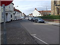
The Pavement Looking to George Street
Taken from the corner of Railway street looking up the pavement to George Street.
Image: © Keith Laverack
Taken: 14 Mar 2008
0.02 miles
2
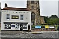
Pocklington, All Saints Church and Hair Salon
Image: © Michael Garlick
Taken: 31 Jul 2019
0.02 miles

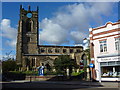


9
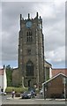
All Saints Church - viewed from Grape Lane
Image: © Betty Longbottom
Taken: 24 May 2011
0.02 miles
