IMAGES TAKEN NEAR TO
Huggate, YORK, YO42 1YW
Introduction
This page details the photographs taken nearby to YO42 1YW by members of the Geograph project.
The Geograph project started in 2005 with the aim of publishing, organising and preserving representative images for every square kilometre of Great Britain, Ireland and the Isle of Man.

There are currently over 7.5m images from over14,400 individuals and you can help contribute to the project by visiting https://www.geograph.org.uk
Image Map
Images are licensed for reuse under creativecommons.org/licenses/by-sa/2.0
Notes
- Clicking on the map will re-center to the selected point.
- The higher the marker number, the further away the image location is from the centre of the postcode.
Image Listing (27 Images Found)
Images are licensed for reuse under creativecommons.org/licenses/by-sa/2.0
Image
Details
Distance
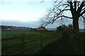
1
Make no mistake, The Wolds Way is to the right
At the western entrance to Glebe Farm.
Image: © Jonathan Thacker
Taken: 23 May 2014
0.03 miles
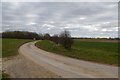
2
The Wolds Way
As it passes Glebe Farm Cottages.
Image: © Peter Church
Taken: 21 Oct 2007
0.03 miles
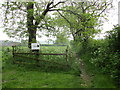
4
Footpath near Glebe Farm
Looking along a path leading to Church Street in Huggate.
Image: © DS Pugh
Taken: 12 Nov 2022
0.03 miles
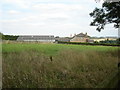
5
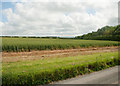
Wheatfield looking ENE from track to Glebe Farm
Image: © Neil Oakes
Taken: 3 Jul 2012
0.06 miles
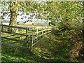
6
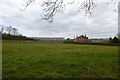
Glebe Farm
Looking across to Glebe Farm from the Yorkshire Wolds Way.
Image: © DS Pugh
Taken: 21 Mar 2016
0.07 miles
7
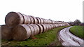
The Road to Glebe Farm Cottages
And the number of rolls has doubled since Image
Image: © Christine Church
Taken: 21 Oct 2007
0.07 miles
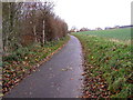
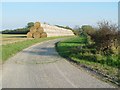
9
Track to Glebe Farm
Also forming part of the Yorkshire Wolds Way.
Image: © DS Pugh
Taken: 21 Mar 2016
0.09 miles