IMAGES TAKEN NEAR TO
Warter, YORK, YO42 1XU
Introduction
This page details the photographs taken nearby to YO42 1XU by members of the Geograph project.
The Geograph project started in 2005 with the aim of publishing, organising and preserving representative images for every square kilometre of Great Britain, Ireland and the Isle of Man.

There are currently over 7.5m images from over14,400 individuals and you can help contribute to the project by visiting https://www.geograph.org.uk
Image Map (Loading...)


Getting Data...Please wait
Leaflet Map data © OpenStreetMap
Images are licensed for reuse under creativecommons.org/licenses/by-sa/2.0
Notes
- Clicking on the map will re-center to the selected point.
- The higher the marker number, the further away the image location is from the centre of the postcode.
Image Listing (9 Images Found)
Images are licensed for reuse under creativecommons.org/licenses/by-sa/2.0
Image
Details
Distance
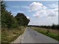
1
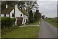
Loaningdale cottages, near Warter
East Loaningdale Cottage nearest the camera. The belt of trees which is shown on the north side of the lane on the OS map has recently been completely felled.
Image: © Paul Harrop
Taken: 18 Oct 2009
0.03 miles
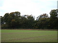
3
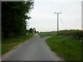
Road Junction Loaningdale , Looking SW
Image: © Charles Rispin
Taken: 10 Sep 2006
0.16 miles
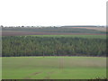
9
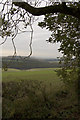
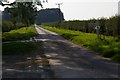
Nunburnholme Wold
Looking across farmland from just west of Loaningdale
Image: © Paul Harrop
Taken: 18 Oct 2009
0.25 miles