IMAGES TAKEN NEAR TO
Warter, YORK, YO42 1XD
Introduction
This page details the photographs taken nearby to YO42 1XD by members of the Geograph project.
The Geograph project started in 2005 with the aim of publishing, organising and preserving representative images for every square kilometre of Great Britain, Ireland and the Isle of Man.

There are currently over 7.5m images from over14,400 individuals and you can help contribute to the project by visiting https://www.geograph.org.uk
Image Map
Images are licensed for reuse under creativecommons.org/licenses/by-sa/2.0
Notes
- Clicking on the map will re-center to the selected point.
- The higher the marker number, the further away the image location is from the centre of the postcode.
Image Listing (3 Images Found)
Images are licensed for reuse under creativecommons.org/licenses/by-sa/2.0
Image
Details
Distance
1
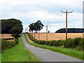
Cobdale Lane
One of many minor roads in the undulating area of the Yorkshire Wolds.
Image: © Andy Beecroft
Taken: 13 Aug 2011
0.17 miles
2
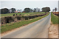
Cobdale Lane
The lane here runs northeast across the gentle rise of Cobdale, and provides access to Cobdale farm which can be seen amongst a protective surround of trees.
Image: © Peter Church
Taken: 22 Mar 2009
0.19 miles
3
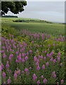
Cold Wold, near Millington
Living up to its name, even in mid-July, seen here from Cobdale Lane, looking in the direction of Sylvan Dale
Image: © Paul Harrop
Taken: 18 Jul 2010
0.24 miles