IMAGES TAKEN NEAR TO
Kilnwick Percy, YORK, YO42 1UF
Introduction
This page details the photographs taken nearby to YO42 1UF by members of the Geograph project.
The Geograph project started in 2005 with the aim of publishing, organising and preserving representative images for every square kilometre of Great Britain, Ireland and the Isle of Man.

There are currently over 7.5m images from over14,400 individuals and you can help contribute to the project by visiting https://www.geograph.org.uk
Image Map
Images are licensed for reuse under creativecommons.org/licenses/by-sa/2.0
Notes
- Clicking on the map will re-center to the selected point.
- The higher the marker number, the further away the image location is from the centre of the postcode.
Image Listing (32 Images Found)
Images are licensed for reuse under creativecommons.org/licenses/by-sa/2.0
Image
Details
Distance
1
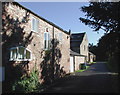
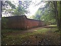
Home Farm, Kilnwick Percy
Some of the old farm buildings at Home Farm, many of which have now been converted into housing.
Image: © Paul Glazzard
Taken: 17 Oct 2007
0.02 miles
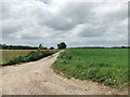
3
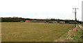
Home Farm Field, Kilnwick Percy
The wood on the skyline is called "Jenny Firkin Wood", see http://en.wikipedia.org/wiki/Firkin for information on the "Firkin".
Image: © Peter Church
Taken: 18 Mar 2008
0.04 miles
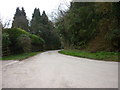
4
Kilnwick Percy Cottages
The cottages look as if they belong(ed) to Kilnwick Percy Hall.
Image: © Peter Church
Taken: 18 Mar 2008
0.05 miles
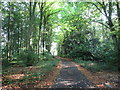
7
Woodland walk, Kilnwick Percy Hall
Peaceful walk in the grounds of the Madhyamaka Buddhist Centre.
Image: © JThomas
Taken: 30 Aug 2019
0.16 miles
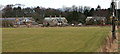
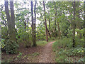
9
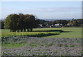
Home Farm, Kilnwick Percy
Looking southwest towards Home Farm from the edge of Jenny Firkin Wood. Three of Yorkshire's huge coal-fired power stations are just about visible on the hazy distant horizon: Drax on the far left, Eggborough just peeking out to the right of the clump of trees in the foreground, and Ferrybridge on the extreme right.
Image: © Paul Glazzard
Taken: 17 Oct 2007
0.17 miles
10
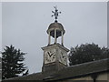
Clock Tower, Kilnwick Percy Hall near Pocklington, East Riding, Yorkshire
A Clock Tower on a building on the grounds of the Madhyamaka Buddhist Centre, Kilnwick Percy Hall, Pocklington, East Riding, East Yorkshire. The building is in fact a sort of guest house and retreat.
Image: © Eamon Curry
Taken: 1 Jan 2010
0.17 miles