IMAGES TAKEN NEAR TO
Bishop Wilton, YORK, YO42 1TB
Introduction
This page details the photographs taken nearby to YO42 1TB by members of the Geograph project.
The Geograph project started in 2005 with the aim of publishing, organising and preserving representative images for every square kilometre of Great Britain, Ireland and the Isle of Man.

There are currently over 7.5m images from over14,400 individuals and you can help contribute to the project by visiting https://www.geograph.org.uk
Image Map
Images are licensed for reuse under creativecommons.org/licenses/by-sa/2.0
Notes
- Clicking on the map will re-center to the selected point.
- The higher the marker number, the further away the image location is from the centre of the postcode.
Image Listing (28 Images Found)
Images are licensed for reuse under creativecommons.org/licenses/by-sa/2.0
Image
Details
Distance
2
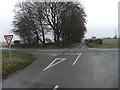
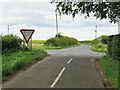
Road junction, Greenwick Cottage
Crossing the photograph is a C road from the A166 to Pocklington. Running away from the camera is the minor road on which Image is taken. Behind the finger post is a concrete feature shown in more detail in Image
Image: © Christopher Hall
Taken: 1 Sep 2014
0.03 miles
3
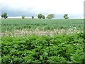
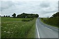
Farmland north of Greenwick Cottage
The trees mark the route of the A166.
Image: © Christine Johnstone
Taken: 22 Jun 2013
0.04 miles
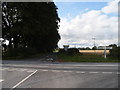
4
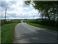
Crossroads near Greenwick Lodge
Looking along the road leading to Millington.
Image: © DS Pugh
Taken: 20 Jun 2020
0.04 miles
5
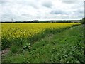
Western edge of oilseed rape field
East of Greenwick Cottage.
Image: © Christine Johnstone
Taken: 22 Jun 2013
0.04 miles
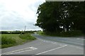
6
Road near Greenwick Cottage
Looking along the road between Millington and the A166.
Image: © DS Pugh
Taken: 20 Jun 2020
0.04 miles
8
Road junction by Greenwick Cottage
An almost identical shot to one taken by J Thomas in 2010. Here the minor road towards Huggate crosses the much busier Pockington to Fridaythorpe road.
Image: © Gordon Hatton
Taken: 5 Jul 2023
0.05 miles
9
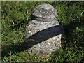
Bollard, High Callis Wold
See Image for context. I would have called it a boundary stone,
but Christopher Hall describes it as a concrete bollard Image and provides an explanation.
Image: © Stephen Craven
Taken: 8 Jul 2017
0.05 miles
10
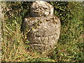
Concrete feature a Greenwick Cottage junction
This concrete bollard is behind the finger post shown in Image It is one of several bell shaped concrete bollards with Latin inscriptions along roads in the area. These were placed by Mr Newark Andrews, a local farmer, in the 1960’s to mark the entrance to his fields.
Image: © Christopher Hall
Taken: 1 Sep 2014
0.05 miles