IMAGES TAKEN NEAR TO
Fangfoss, YORK, YO41 5QB
Introduction
This page details the photographs taken nearby to YO41 5QB by members of the Geograph project.
The Geograph project started in 2005 with the aim of publishing, organising and preserving representative images for every square kilometre of Great Britain, Ireland and the Isle of Man.

There are currently over 7.5m images from over14,400 individuals and you can help contribute to the project by visiting https://www.geograph.org.uk
Image Map
Images are licensed for reuse under creativecommons.org/licenses/by-sa/2.0
Notes
- Clicking on the map will re-center to the selected point.
- The higher the marker number, the further away the image location is from the centre of the postcode.
Image Listing (4 Images Found)
Images are licensed for reuse under creativecommons.org/licenses/by-sa/2.0
Image
Details
Distance
1
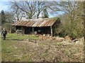
Old log store at Fangfoss Grange
On footpath from Spittal
Image: © Martin Dawes
Taken: 14 Mar 2016
0.04 miles
2
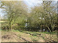
Pond at Fangfoss Grange
From the track from farm to road alongside Crow Wood
Image: © Martin Dawes
Taken: 14 Mar 2016
0.08 miles
3
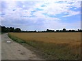
Path to Fangfoss Grange
Part of the footpath to Fangfoss Grange.
Image: © DS Pugh
Taken: 30 Jul 2006
0.19 miles
4
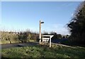
Footpath sign at entrance to Fangfoss Grange
Image: © David Brown
Taken: 26 Nov 2021
0.25 miles