IMAGES TAKEN NEAR TO
Stonebridge Drive, YORK, YO41 5PQ
Introduction
This page details the photographs taken nearby to Stonebridge Drive, YO41 5PQ by members of the Geograph project.
The Geograph project started in 2005 with the aim of publishing, organising and preserving representative images for every square kilometre of Great Britain, Ireland and the Isle of Man.

There are currently over 7.5m images from over14,400 individuals and you can help contribute to the project by visiting https://www.geograph.org.uk
Image Map (Loading...)


Getting Data...Please wait
Leaflet Map data © OpenStreetMap
Images are licensed for reuse under creativecommons.org/licenses/by-sa/2.0
Notes
- Clicking on the map will re-center to the selected point.
- The higher the marker number, the further away the image location is from the centre of the postcode.
Image Listing (89 Images Found)
Images are licensed for reuse under creativecommons.org/licenses/by-sa/2.0
Image
Details
Distance
1
Stonebridge Drive Wilberfoss
Looking west from Main Street houses in Pear Tree Close (relatively new) can be seen over the hedge in the distance.
Image: © Keith Laverack
Taken: 8 Dec 2009
0.02 miles
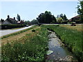
2
Wilberfoss East Entrance
This shows the east entrance to Wilberfoss from the A1079 in winter. See Image for Spring View.
Image: © Keith Laverack
Taken: 20 Feb 2010
0.02 miles
3
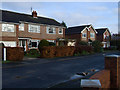
Stonebridge Drive Wilberfoss
Houses on north side of road. Photo taken facing east.
Image: © Keith Laverack
Taken: 8 Dec 2009
0.02 miles
4
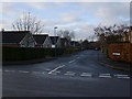
Stonebridge Drive Wilberfoss
Taken from Main Street looking west down Stonebridge Drive
Image: © Keith Laverack
Taken: 8 Dec 2009
0.02 miles
5
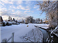
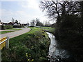
Snow Returns To Wilberfoss
Looking South towards the A1079 from Butcher Bridge with Main Street on the right of Foss Beck. On the left of the beck is Beckside with Willow Park Road leading off to the left.
Image: © Keith Laverack
Taken: 31 Dec 2009
0.04 miles
7
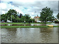
Floods June 2007
This view is taken from the Junction of Willow Park Road looking across Foss Beck towards Main Street. The water on the far side of the bank is the Beck flooded over the bank at that side. The water in the foreground is water which has backed up the road drains on Beckside and flooded the street.
Image: © Keith Laverack
Taken: 26 Jun 2007
0.05 miles
8
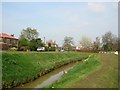
The beck
Taken from Beckside, looking across the village green.
Image: © DS Pugh
Taken: 12 Apr 2007
0.05 miles
9
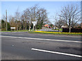
Wilberfoss In Bloom
The Easterly entrance to Wilberfoss from A1079. The daffodils are the work of the Wilberfoss in Bloom Committee who planted them.See Image for winter view.
Image: © Keith Laverack
Taken: 31 Mar 2008
0.06 miles