IMAGES TAKEN NEAR TO
Millfield Close, YORK, YO41 5PP
Introduction
This page details the photographs taken nearby to Millfield Close, YO41 5PP by members of the Geograph project.
The Geograph project started in 2005 with the aim of publishing, organising and preserving representative images for every square kilometre of Great Britain, Ireland and the Isle of Man.

There are currently over 7.5m images from over14,400 individuals and you can help contribute to the project by visiting https://www.geograph.org.uk
Image Map (Loading...)


Getting Data...Please wait
Leaflet Map data © OpenStreetMap
Images are licensed for reuse under creativecommons.org/licenses/by-sa/2.0
Notes
- Clicking on the map will re-center to the selected point.
- The higher the marker number, the further away the image location is from the centre of the postcode.
Image Listing (41 Images Found)
Images are licensed for reuse under creativecommons.org/licenses/by-sa/2.0
Image
Details
Distance
1
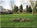
Grassed area, Storking Lane, Wilberfoss
Wilberfoss has a very active "Wilberfoss in Bloom" group whose activities are clearly on display here.
Image: © Jonathan Thacker
Taken: 14 Apr 2018
0.06 miles
2

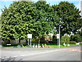
Storking Lane, Wilberfoss
Road junction in Wilberfoss. In both directions the A1079 can be accessed, the main village however is left.
Image: © DS Pugh
Taken: 12 Apr 2007
0.06 miles
3

Main Street Storking Lane Junction
Taken from Storking Lane facing South
Image: © Keith Laverack
Taken: 24 Apr 2007
0.06 miles
7

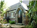
The Villa, Wilberfoss
Dates from the 1880s.
Image: © Jonathan Thacker
Taken: 14 Apr 2018
0.09 miles

10
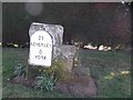
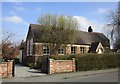
Old Milestone by Windmill Hill, Wilberfoss
Metal plate attached to stone post by the UC road, in parish of WILBERFOSS (EAST RIDING OF YORKSHIRE District), Windmill Hill, Wilberfoss, on well kept verge, on South side of road. Beverley Mounting block, 3 step, erected by the Beverley to Kexby Bridge turnpike trust in the 18th/19th century. Re-located from cut off old road further West after 2011.
Inscription reads:-
21
BEVERLEY
8
YORK
Milestone Society National ID: YE_YOBV08.
Image: © John Harland
Taken: Unknown
0.11 miles