IMAGES TAKEN NEAR TO
Kexby, YORK, YO41 5LE
Introduction
This page details the photographs taken nearby to YO41 5LE by members of the Geograph project.
The Geograph project started in 2005 with the aim of publishing, organising and preserving representative images for every square kilometre of Great Britain, Ireland and the Isle of Man.

There are currently over 7.5m images from over14,400 individuals and you can help contribute to the project by visiting https://www.geograph.org.uk
Image Map (Loading...)


Getting Data...Please wait
Leaflet Map data © OpenStreetMap
Images are licensed for reuse under creativecommons.org/licenses/by-sa/2.0
Notes
- Clicking on the map will re-center to the selected point.
- The higher the marker number, the further away the image location is from the centre of the postcode.
Image Listing (22 Images Found)
Images are licensed for reuse under creativecommons.org/licenses/by-sa/2.0
Image
Details
Distance
1
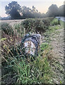
Old Milestone by the A1079, west of Arnull Bridge, Catton parish
Metal plate attached to stone post by the A1079, in parish of CATTON (EAST RIDING OF YORKSHIRE District), just West of Catton Lane junction, back of verge, on South side of road. Beverley Mounting block, 3 step, erected by the Beverley to Kexby Bridge turnpike trust in the 18th/19th century. An earlier photograph can be found here https://www.geograph.org.uk/photo/6060924.
Inscription reads:-
22
BEVERLEY
7
YORK
Rivet on top step.
Milestone Society National ID: YE_YOBV07.
Image: © Nigel Upton
Taken: 28 Jul 2023
0.07 miles
2

Old Milestone by the A1079, west of Arnull Bridge, Catton parish
Metal plate attached to stone post by the A1079, in parish of CATTON (EAST RIDING OF YORKSHIRE District), just West of Catton Lane junction, back of verge, on South side of road. Beverley Mounting block, 3 step, erected by the Beverley to Kexby Bridge turnpike trust in the 18th/19th century.
Inscription reads:-
22
BEVERLEY
7
YORK
Rivet on top step.
Milestone Society National ID: YE_YOBV07.
Image: © John Harland
Taken: 1 May 2002
0.07 miles
3
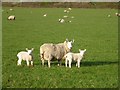
Sheep and lambs
In a field near Kexby from the bridleway running to Low Catton. Ahead the road to Low Catton can be seen over the hedge.
Image: © DS Pugh
Taken: 22 Apr 2010
0.11 miles
4
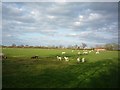
Sheep near Kexby
This bridleway runs from Kexby to Low Catton, just to the east of the River Derwent.
Image: © DS Pugh
Taken: 22 Apr 2010
0.11 miles
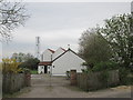
5
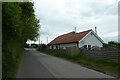
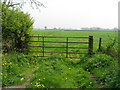
The Croft
Looking towards the junction with the A1079 on Long Lane.
Image: © DS Pugh
Taken: 22 May 2022
0.15 miles
6

Bridleway to Low Catton
This bridleway runs to Low Catton from Kexby. The fields are full of new born lambs.
Image: © DS Pugh
Taken: 22 Apr 2010
0.15 miles
7
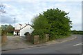
Garden Cottage
Standing at the junction of Long Lane and Hull Road.
Image: © DS Pugh
Taken: 17 Apr 2017
0.16 miles
9
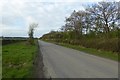
Long Lane
Looking along Long Lane between Hull Road and High Catton.
Image: © DS Pugh
Taken: 17 Apr 2017
0.19 miles