IMAGES TAKEN NEAR TO
Sutton Park, YORK, YO41 4JY
Introduction
This page details the photographs taken nearby to Sutton Park, YO41 4JY by members of the Geograph project.
The Geograph project started in 2005 with the aim of publishing, organising and preserving representative images for every square kilometre of Great Britain, Ireland and the Isle of Man.

There are currently over 7.5m images from over14,400 individuals and you can help contribute to the project by visiting https://www.geograph.org.uk
Image Map (Loading...)


Getting Data...Please wait
Leaflet Map data © OpenStreetMap
Images are licensed for reuse under creativecommons.org/licenses/by-sa/2.0
Notes
- Clicking on the map will re-center to the selected point.
- The higher the marker number, the further away the image location is from the centre of the postcode.
Image Listing (39 Images Found)
Images are licensed for reuse under creativecommons.org/licenses/by-sa/2.0
Image
Details
Distance
1
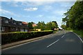
Road closure signs in Sutton
Hagg Bridge is closed for 6 months.
Image: © DS Pugh
Taken: 20 Jun 2020
0.05 miles
2
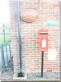
Sutton on Derwent: postbox № YO41 196
This George VI-reign postbox stands outside the village hall, one of whose rooms accommodates the post office which is open on weekday mornings. Most maps call the place Sutton upon Derwent while the Royal Mail refers to it as Sutton on Derwent.
Image: © Chris Downer
Taken: 12 Dec 2011
0.05 miles
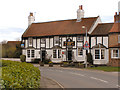
3
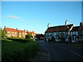
St Vincent Arms
One of the pubs in Sutton upon Derwent. This village has been partly cut off at the time of my visit, due to Elvington being impassable to cars from the flooding.
Image: © DS Pugh
Taken: 29 Jun 2007
0.05 miles
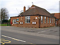
6

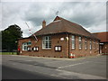
Tennis club in Sutton upon Derwent
At the junction of Sandhill Lane and Main Street.
Image: © DS Pugh
Taken: 13 Jun 2023
0.05 miles
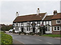
7
St Vincent Arms
Main Street, Sutton Upon Derwent
Image: © David Dixon
Taken: 5 Apr 2010
0.06 miles
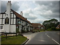
8
The St Vincent Arms, Sutton upon Derwent
A pleasant country inn that was voted as York CAMRA's Pub of the Year 2006. Anyone for a pint of real ale?
Image: © Gordon Hatton
Taken: 4 Mar 2007
0.07 miles
10
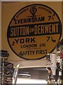
Old circular AA sign in the St Vincent Arms, Sutton on Derwent
Old AA Sign above the bar in the St Vincent Arms PH on the west side of the B1228 Main Street in Sutton upon Derwent, 7½ miles southeast of York. Sutton upon Derwent parish.
This is the circular, village name on black band, no Motor Union symbol or name type dating from 1923 and showing distances Everingham 7½ York 7½ London 216.
There were five series of AA signs, mostly dating from 1923 and made by Francis & Co / Franco in Deptford, London. The village name and distance to London were usually displayed.
Milestone Society National ID: YO-SUTDER
Image: © Milestone Society
Taken: Unknown
0.07 miles