IMAGES TAKEN NEAR TO
YO41 4EU
Introduction
This page details the photographs taken nearby to YO41 4EU by members of the Geograph project.
The Geograph project started in 2005 with the aim of publishing, organising and preserving representative images for every square kilometre of Great Britain, Ireland and the Isle of Man.

There are currently over 7.5m images from over14,400 individuals and you can help contribute to the project by visiting https://www.geograph.org.uk
Image Map (Loading...)


Getting Data...Please wait
Leaflet Map data © OpenStreetMap
Images are licensed for reuse under creativecommons.org/licenses/by-sa/2.0
Notes
- Clicking on the map will re-center to the selected point.
- The higher the marker number, the further away the image location is from the centre of the postcode.
Image Listing (12 Images Found)
Images are licensed for reuse under creativecommons.org/licenses/by-sa/2.0
Image
Details
Distance
2
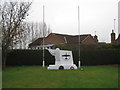
Free French War Memorial
Wreaths rather blown about by the wind.
Image: © Jonathan Thacker
Taken: 30 Dec 2011
0.19 miles
3
Memorial to Free French Aircrew
This memorial commemorates the Free French aircrew based at Elvington Airfield in World War II. More about them at; https://tailendcharlietedchurch.wordpress.com/raf-stations/77-squadron-elvington/elvington-4344/french/
Image: © Chris Morgan
Taken: 3 Oct 2022
0.20 miles
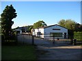
4
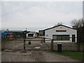
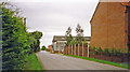
Flatford's Engineering Works, Elvington
There are a number of industrial units in Elvington, spread out along the York road.
Image: © Gordon Hatton
Taken: 4 Mar 2007
0.20 miles
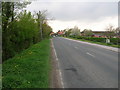
6
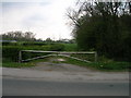
Site of former Elvington station, 1993
View northward on the B1228 road, towards York: former Derwent Valley Light Railway. The station closed and the passenger service (York Layerthorpe - Cliffe Common) ceased 1/9/26, but goods were handled here until 30/9/72 and the line did not close entirely until 27/9/81. (See also Image]).
Image: © Ben Brooksbank
Taken: 3 Sep 1993
0.21 miles
7
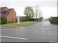
Elvington railway station (site), Yorkshire
Opened in 1913 by the Derwent Valley Light Railway on the line from York (Layerthorpe) to Cliffe Common, this station closed to passengers in 1926 and completely in 1972.
View north towards Dunnington and York. The single line crossed the road by a level crossing to the left of the image, the platform and single storey station building were across the road, just beyond the wall. No trace apparently remains.
Image: © Nigel Thompson
Taken: 27 Apr 2019
0.21 miles
8

War Memorial at Elvington
An unusual memorial erected in memory of Free French aircrew based at nearby Elvington Airfield in WW2. The aircraft shape is that of a Halifax bomber. Both British and French flags occasionally fly from the flagpoles.
Image: © Gordon Hatton
Taken: 4 Mar 2007
0.21 miles
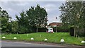
10
Flatford
A building on the outskirts of Elvington. I think this is the course of the old and long dismantled Derwent Valley Light Railway.
Image: © DS Pugh
Taken: 29 Jun 2007
0.23 miles