IMAGES TAKEN NEAR TO
Long Moor Chase, YORK, YO41 1SJ
Introduction
This page details the photographs taken nearby to Long Moor Chase, YO41 1SJ by members of the Geograph project.
The Geograph project started in 2005 with the aim of publishing, organising and preserving representative images for every square kilometre of Great Britain, Ireland and the Isle of Man.

There are currently over 7.5m images from over14,400 individuals and you can help contribute to the project by visiting https://www.geograph.org.uk
Image Map (Loading...)


Getting Data...Please wait
Leaflet Map data © OpenStreetMap
Images are licensed for reuse under creativecommons.org/licenses/by-sa/2.0
Notes
- Clicking on the map will re-center to the selected point.
- The higher the marker number, the further away the image location is from the centre of the postcode.
Image Listing (4 Images Found)
Images are licensed for reuse under creativecommons.org/licenses/by-sa/2.0
Image
Details
Distance
1

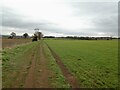
Along the Roman Road
The A166 to Bridlington leaves Stamford Bridge.
Image: © Pauline E
Taken: 26 Aug 2012
0.16 miles
2
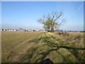
Footpath over a battlefield toward Stamford Bridge
The battle was in 1066 and the site was supposedly on the fields to the left
Image: © Martin Dawes
Taken: 14 Mar 2016
0.18 miles
3
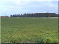
Battle site to east of Stamford Bridge
This photograph was taken from Moor Lane looking north northeast across fields toward the wooded area south of Burtonfield Hall. The field in the shot forms part of the site which was the battle of Stamford Bridge.
Image: © bernard bradley
Taken: 1 Apr 2008
0.22 miles