IMAGES TAKEN NEAR TO
Holly Close, YORK, YO41 1LY
Introduction
This page details the photographs taken nearby to Holly Close, YO41 1LY by members of the Geograph project.
The Geograph project started in 2005 with the aim of publishing, organising and preserving representative images for every square kilometre of Great Britain, Ireland and the Isle of Man.

There are currently over 7.5m images from over14,400 individuals and you can help contribute to the project by visiting https://www.geograph.org.uk
Image Map (8 Images)


Getting Data...Please wait
Leaflet Map data © OpenStreetMap
Images are licensed for reuse under creativecommons.org/licenses/by-sa/2.0
Notes
- Clicking on the map will re-center to the selected point.
- The higher the marker number, the further away the image location is from the centre of the postcode.
Image Listing (8 Images Found)
Images are licensed for reuse under creativecommons.org/licenses/by-sa/2.0
Image
Details
Distance
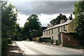
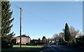
1

Path to Grange Close
Crossing a small park beside Moor Lane.
Image: © DS Pugh
Taken: 26 Nov 2022
0.17 miles
3
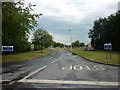
Entrance to HMP Full Sutton.
From Moor Lane the minor road toward Stamford Bridge.
Image: © Martin Dawes
Taken: 4 May 2010
0.18 miles
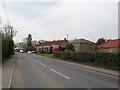
4
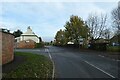
Moor Lane meets Hatkill Lane
A road junction in Full Sutton.
Image: © DS Pugh
Taken: 26 Nov 2022
0.19 miles
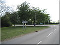
7
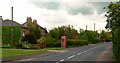
Telephone Box
A public telephone box in Full Sutton. The view point is near to a road junction that has a turning to the A166 trunk road.
Image: © Alan Walker
Taken: 21 May 2005
0.24 miles
8
Full Sutton
The phone box is empty. No phone, no AED and no library.
Image: © David Brown
Taken: 26 Nov 2021
0.25 miles