IMAGES TAKEN NEAR TO
Bridlington Road, YORK, YO41 1HL
Introduction
This page details the photographs taken nearby to Bridlington Road, YO41 1HL by members of the Geograph project.
The Geograph project started in 2005 with the aim of publishing, organising and preserving representative images for every square kilometre of Great Britain, Ireland and the Isle of Man.

There are currently over 7.5m images from over14,400 individuals and you can help contribute to the project by visiting https://www.geograph.org.uk
Image Map (Loading...)


Getting Data...Please wait
Leaflet Map data © OpenStreetMap
Images are licensed for reuse under creativecommons.org/licenses/by-sa/2.0
Notes
- Clicking on the map will re-center to the selected point.
- The higher the marker number, the further away the image location is from the centre of the postcode.
Image Listing (4 Images Found)
Images are licensed for reuse under creativecommons.org/licenses/by-sa/2.0
Image
Details
Distance
1
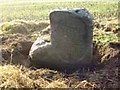
Old Milestone by the A166, Full Sutton parish
Stone post (plate lost) by the A166, in parish of FULL SUTTON (EAST RIDING OF YORKSHIRE District), just West of Full Sutton junction, on open verge, on South side of road. York Mounting block and plate, erected by the York to Kexby Bridge & Grimston to Stonedale End turnpike trust in the 19th century.
Inscription once read:-
(YORK)
(10)
(MILES)
Carved benchmark and rivet on first step.
Milestone Society National ID: YE_YODR10.
Image: © J Harland
Taken: 1 Oct 2001
0.19 miles
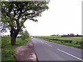
4
30 mph limit
Approaching Skirpenbeck from Dolegate.
Image: © DS Pugh
Taken: 20 Apr 2014
0.25 miles