IMAGES TAKEN NEAR TO
Roman Avenue South, YORK, YO41 1EZ
Introduction
This page details the photographs taken nearby to Roman Avenue South, YO41 1EZ by members of the Geograph project.
The Geograph project started in 2005 with the aim of publishing, organising and preserving representative images for every square kilometre of Great Britain, Ireland and the Isle of Man.

There are currently over 7.5m images from over14,400 individuals and you can help contribute to the project by visiting https://www.geograph.org.uk
Image Map (Loading...)


Getting Data...Please wait
Leaflet Map data © OpenStreetMap
Images are licensed for reuse under creativecommons.org/licenses/by-sa/2.0
Notes
- Clicking on the map will re-center to the selected point.
- The higher the marker number, the further away the image location is from the centre of the postcode.
Image Listing (20 Images Found)
Images are licensed for reuse under creativecommons.org/licenses/by-sa/2.0
Image
Details
Distance
1
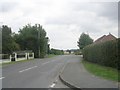
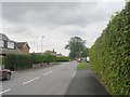
High Catton Road - viewed from Fossway
Image: © Betty Longbottom
Taken: 30 Jul 2011
0.08 miles
2
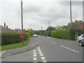
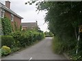
High Catton Road - viewed from Fossway
Image: © Betty Longbottom
Taken: 30 Jul 2011
0.08 miles
6
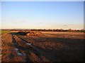
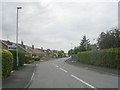
From the High Catton road
The trees show the course of the long since dismantled railway line from York.
Image: © DS Pugh
Taken: 26 Nov 2006
0.15 miles

10
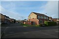
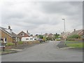
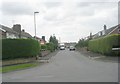
Post box on Goodwinsway
Looking along a residential street in Stamford Bridge.
Image: © DS Pugh
Taken: 26 Nov 2022
0.17 miles