IMAGES TAKEN NEAR TO
York Road, YORK, YO41 1AH
Introduction
This page details the photographs taken nearby to York Road, YO41 1AH by members of the Geograph project.
The Geograph project started in 2005 with the aim of publishing, organising and preserving representative images for every square kilometre of Great Britain, Ireland and the Isle of Man.

There are currently over 7.5m images from over14,400 individuals and you can help contribute to the project by visiting https://www.geograph.org.uk
Image Map
Images are licensed for reuse under creativecommons.org/licenses/by-sa/2.0
Notes
- Clicking on the map will re-center to the selected point.
- The higher the marker number, the further away the image location is from the centre of the postcode.
Image Listing (29 Images Found)
Images are licensed for reuse under creativecommons.org/licenses/by-sa/2.0
Image
Details
Distance
1
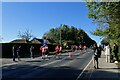
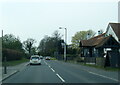
Fourteen mile marker
The road is closed for the Yorkshire Marathon with this section being between 13 and 14 miles for the runners heading towards Stamford Bridge and the 14 mile marker for those heading west having gone around the loop.
Image: © DS Pugh
Taken: 15 Oct 2023
0.01 miles
2

The railway bridge at Stamford Bridge
This structure still stands firm forty years since the Hull to York railway line ran over it. There are plans afoot to possibly use it once again in the future perhaps for the same purpose.
Image: © Andy Beecroft
Taken: 12 May 2005
0.04 miles

4
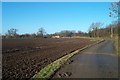
Derwent Dale
View across field towards Derwent Dale, near Stamford Bridge.
Image: © Darren Haddock
Taken: 26 Nov 2001
0.06 miles
5
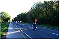
Marathon racers on the A166
The road is closed for the Yorkshire Marathon with this section being between 13 and 14 miles.
Image: © DS Pugh
Taken: 15 Oct 2023
0.08 miles
6
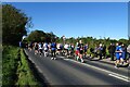
Marathon runners near Stamford Bridge
The road is closed for the Yorkshire Marathon with this section being bidirectional with runners first heading towards Stamford Bridge before doubling back.
Image: © DS Pugh
Taken: 15 Oct 2023
0.08 miles
7
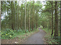
Cycle route alongside the A166
The narrow belt of trees either side of this cycle path screens the two- and four-wheeled traffic from each other quite effectively. The path is part of Route 66 (Transpennine and Way of the Roses routes)
Image: © Stephen Craven
Taken: 7 Jul 2017
0.08 miles
8
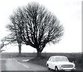
Waymark Chestnut
This tree was a waymarker on the A166 being at the junction of the unclassified road that leads via Buttercrambe to Malton, a pleasant country route over the Wolds.
Image: © Gerald England
Taken: Unknown
0.15 miles
10
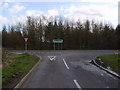
A166 Stamford Bridge West at The Three Cups
Image: © Colin Pyle
Taken: 26 Apr 2021
0.19 miles