IMAGES TAKEN NEAR TO
Rolston Avenue, YORK, YO31 9JD
Introduction
This page details the photographs taken nearby to Rolston Avenue, YO31 9JD by members of the Geograph project.
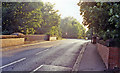
The Geograph project started in 2005 with the aim of publishing, organising and preserving representative images for every square kilometre of Great Britain, Ireland and the Isle of Man.

There are currently over 7.5m images from over14,400 individuals and you can help contribute to the project by visiting https://www.geograph.org.uk
Image Map
Images are licensed for reuse under creativecommons.org/licenses/by-sa/2.0
Notes
- Clicking on the map will re-center to the selected point.
- The higher the marker number, the further away the image location is from the centre of the postcode.
Image Listing (20 Images Found)
Images are licensed for reuse under creativecommons.org/licenses/by-sa/2.0
Image
Details
Distance
1
Doriam Drive
Looking along Doriam Drive with Doriam Avenue on the left.
Image: © DS Pugh
Taken: 23 Jun 2019
0.13 miles
2
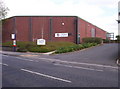
New Earswick Bowls Club
Large Bowls/Restaurant/Function facility on Huntington Road.
Image: © Weston Beggard
Taken: 29 Apr 2006
0.15 miles
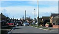
3
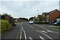
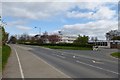
Stratford Way
Looking along a street in the Huntington area.
Image: © DS Pugh
Taken: 23 Jun 2019
0.15 miles
4
Earswick railway station (site), Yorkshire
Opened in 1847 by the North Eastern Railway on the line from Beverley to York, this station closed in 1965. View north east across the former level crossing to the station site - a modern suburban pub now stands where the village station building was.
Image: © Nigel Thompson
Taken: 9 Dec 2012
0.16 miles
5
Earswick: approximate site of former station, 1991
View SW, where the road crosses the course of the former ex-NER York - Market Weighton - Hull line, just east of its junction with the York - Scarborough line. Along with Earswick station the line to Market Weighton had closed from 29/11/65.
Image: © Ben Brooksbank
Taken: 30 Aug 1991
0.17 miles
6
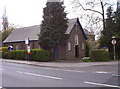
St Andrews Church
St Andrews Church, Huntington.
Image: © Weston Beggard
Taken: 29 Apr 2006
0.18 miles
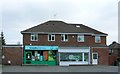
7
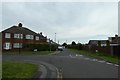
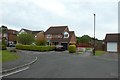
Brockfield Park Drive
Typical York suburb with semi detached houses of the 1950's, together with a small row of shops seen to the left and a corner of the local 'chippy' to the right.
Image: © Gordon Hatton
Taken: 14 Mar 2023
0.18 miles
9
Path to New Lane
Looking towards a cycle path linking Stratford Way to New Lane.
Image: © DS Pugh
Taken: 23 Jun 2019
0.21 miles
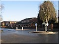
10
Huntington School
Situated on Huntington Road.
Image: © DS Pugh
Taken: 13 Apr 2014
0.22 miles