IMAGES TAKEN NEAR TO
Faber Street, YORK, YO31 7XH
Introduction
This page details the photographs taken nearby to Faber Street, YO31 7XH by members of the Geograph project.
The Geograph project started in 2005 with the aim of publishing, organising and preserving representative images for every square kilometre of Great Britain, Ireland and the Isle of Man.

There are currently over 7.5m images from over14,400 individuals and you can help contribute to the project by visiting https://www.geograph.org.uk
Image Map
Images are licensed for reuse under creativecommons.org/licenses/by-sa/2.0
Notes
- Clicking on the map will re-center to the selected point.
- The higher the marker number, the further away the image location is from the centre of the postcode.
Image Listing (143 Images Found)
Images are licensed for reuse under creativecommons.org/licenses/by-sa/2.0
Image
Details
Distance

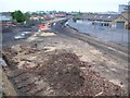
3
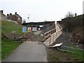
Works on Hallfield Road
This section of cycle route looks very different now. The bridge has been knocked down and the road lowered.
Image: © DS Pugh
Taken: 22 Apr 2006
0.05 miles

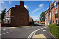
5
Layerthorpe - apartments on Hallfield Road
Image: © Peter Whatley
Taken: 8 Jul 2024
0.06 miles
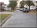
6

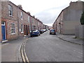
Little Hallfield Road - Hallfield Road
Image: © Betty Longbottom
Taken: 24 May 2017
0.08 miles
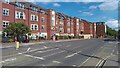
7
Harcourt Street - viewed from Fourth Avenue
Image: © Betty Longbottom
Taken: 17 Oct 2015
0.08 miles

9
What became James Street
Construction works in progress to make James Street a through road on the old council municipal refuse site. This view now is very different.
Image: © DS Pugh
Taken: 14 May 2006
0.08 miles