IMAGES TAKEN NEAR TO
YO3 0PW
Introduction
This page details the photographs taken nearby to YO3 0PW by members of the Geograph project.
The Geograph project started in 2005 with the aim of publishing, organising and preserving representative images for every square kilometre of Great Britain, Ireland and the Isle of Man.

There are currently over 7.5m images from over14,400 individuals and you can help contribute to the project by visiting https://www.geograph.org.uk
Image Map
Images are licensed for reuse under creativecommons.org/licenses/by-sa/2.0
Notes
- Clicking on the map will re-center to the selected point.
- The higher the marker number, the further away the image location is from the centre of the postcode.
Image Listing (82 Images Found)
Images are licensed for reuse under creativecommons.org/licenses/by-sa/2.0
Image
Details
Distance
1
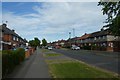
Fifth Avenue
Looking along Fifth Avenue in the Tang Hall area of York.
Image: © DS Pugh
Taken: 2 Jun 2020
0.02 miles
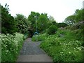
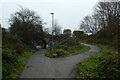
2
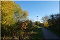
Cycle path approaching Tang Hall Lane
Part of the Foss Islands path.
Image: © DS Pugh
Taken: 3 Dec 2022
0.05 miles
3
Cycle path from Tang Hall Lane
Looking down on the Sustrans cycle path between Osbaldwick and Wiggington Road.
Image: © DS Pugh
Taken: 2 Jun 2020
0.06 miles
4
Sustrans path
Looking along the cycle and foot path leading to Tang Hall and Osbaldwick.
Image: © DS Pugh
Taken: 19 Dec 2021
0.06 miles
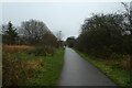
5
Sustrans Route 66 - Tang Hall
This Sustrans national cycle route runs from York out to Beverley. This stretch is on an old railway trackbed which used to form a branch running from a junction with the York - Scarborough line, down through Murton & Weldrake, and then joining back to other branches just to the east of Selby.
As a cycle route, the railway is used between the Nestle chocolate factory and Osbaldwick, beyond Osbaldwick quiet roads take you as far as Market Weighton before joining the old York to Beverley railway.
The bridge in front carries Tang Hall Lane.
Image: © DS Pugh
Taken: 14 May 2006
0.08 miles
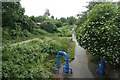
6
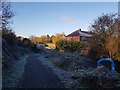
Cycle path access
Looking down the ramp to join the Osbaldwick-Layerthorpe path on a frosty morning.
Image: © DS Pugh
Taken: 30 Nov 2019
0.08 miles
7
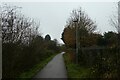
Path towards Melrosegate
Looking along the Sustrans cycle path NCN66.
Image: © DS Pugh
Taken: 19 Dec 2021
0.09 miles
8
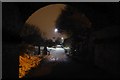
Under the arch
Looking along cycle route 66 in Tang Hall.
Image: © DS Pugh
Taken: 3 Mar 2018
0.09 miles
9
Tang Hall Junction
Looking along Sustrans cycle path NCN66 towards Osbaldwick with the Tang Hall Lane exit on the right.
Image: © DS Pugh
Taken: 19 Dec 2021
0.10 miles
10
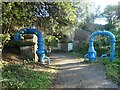
Big Blue Pipe, Tang Hall Lane bridge
One of ten painted steel sculptures by George Cutts, commissioned by Sustrans in the 1980s. Alongside the Foss Island Path, part of NCR route 66. This is the former route of the Derwent Valley Light Railway.
Image: © Christine Johnstone
Taken: 22 Oct 2022
0.10 miles