IMAGES TAKEN NEAR TO
Sycamore Terrace, YORK, YO30 7DN
Introduction
This page details the photographs taken nearby to Sycamore Terrace, YO30 7DN by members of the Geograph project.
The Geograph project started in 2005 with the aim of publishing, organising and preserving representative images for every square kilometre of Great Britain, Ireland and the Isle of Man.

There are currently over 7.5m images from over14,400 individuals and you can help contribute to the project by visiting https://www.geograph.org.uk
Image Map
Images are licensed for reuse under creativecommons.org/licenses/by-sa/2.0
Notes
- Clicking on the map will re-center to the selected point.
- The higher the marker number, the further away the image location is from the centre of the postcode.
Image Listing (1065 Images Found)
Images are licensed for reuse under creativecommons.org/licenses/by-sa/2.0
Image
Details
Distance
1
Almery Terrace York
Riverside housing viewed from riverboat on the Ouse
Image: © Peter Robinson
Taken: 9 Jun 2010
0.05 miles
2
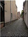
Back alley off Longfield Terrace, York
A well preserved example of a stone setted back alley with central drainage channel, typical of the region. There is a faded sign on the wall "Way In" which presumably refers to some business activity previously carried on here.
Image: © Stephen Craven
Taken: 31 Aug 2015
0.05 miles
3
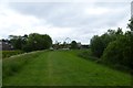
Along the floodbank
Looking towards the York Wheel in the distance.
Image: © DS Pugh
Taken: 9 Jun 2013
0.05 miles
4
Sewage pumping station, Longfield Terrace, York
This is situated at the lowest point of a group of streets near the river, so presumably the sewage is either pumped back up to a main sewer under Clifton Road, or else under the river since York's sewage works is on the south bank Image
Image: © Stephen Craven
Taken: 31 Aug 2015
0.07 miles
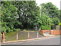
5
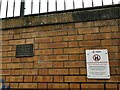
Plaque to Richard Proctor
The small plaque on the side of the rebuilt Scarborough footbridge is a tribute to an engineer who died in 2011 aged only 47. To the right is a City Council notice prohibiting alcohol on the bridge.
Image: © Stephen Craven
Taken: 1 Apr 2023
0.08 miles
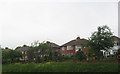
6

Sycamore Place
A fine pair of Victorian houses.
Image: © Michael Dibb
Taken: 20 Jun 2016
0.08 miles
7
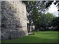
Roman & Medieval city wall
The 'red' bricks in the wall indicate that this part is Roman. The 'regular' cut stone above the Roman section are Medieval.
Image: © Row17
Taken: 3 Aug 2010
0.08 miles
8
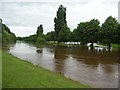
North of Scarborough bridge
The Ouse has broken its banks over the footpaths on the east side of the Ouse. The path runs roughly along the trees.
Image: © DS Pugh
Taken: 26 Jun 2007
0.08 miles
9

Viking Raiders in York or Jorvik
A mock battle is taking place in the Museum Gardens, York.
In Viking times York was called Jorvik (the Scandinavians, still pronounce the J as a Y sound, so it sounds like Yorvik).
The grounds were originally owned by the Yorkshire Philosophical Society, for more details see:
http://www.yorksphilsoc.org.uk/
The building of the Yorkshire Museum can be seen in the distance for more details see:
http://www.yorkshiremuseum.org.uk
Image: © Michael Jagger
Taken: 20 Feb 2010
0.08 miles
10
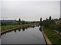
From Scarborough bridge
The view from a train crossing Scarborough bridge. This bridge is shared with pedestrians, who cross on the south side, whereas trains have the northern half.
Image: © DS Pugh
Taken: 21 Aug 2007
0.08 miles