IMAGES TAKEN NEAR TO
St. Peters Grove, YORK, YO30 6AQ
Introduction
This page details the photographs taken nearby to St. Peters Grove, YO30 6AQ by members of the Geograph project.
The Geograph project started in 2005 with the aim of publishing, organising and preserving representative images for every square kilometre of Great Britain, Ireland and the Isle of Man.

There are currently over 7.5m images from over14,400 individuals and you can help contribute to the project by visiting https://www.geograph.org.uk
Image Map
Images are licensed for reuse under creativecommons.org/licenses/by-sa/2.0
Notes
- Clicking on the map will re-center to the selected point.
- The higher the marker number, the further away the image location is from the centre of the postcode.
Image Listing (153 Images Found)
Images are licensed for reuse under creativecommons.org/licenses/by-sa/2.0
Image
Details
Distance
1
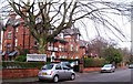
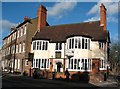
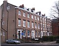
Marmadukes Hotel
Marmadukes is on St Peter's Grove, a cul de sac lined with large red brick Victorian villas, this one having been converted into a hotel.
Image: © Gordon Hatton
Taken: 2 Mar 2012
0.04 miles
2
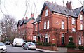
Holme Lea Manor
Described as a 'boutique' bed and breakfast establishment, Holme Lea Manor is one of the large Victorian [circa 1880] properties on St Peter's Grove.
Image: © Gordon Hatton
Taken: 2 Mar 2012
0.04 miles
3
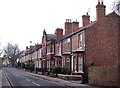
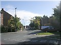
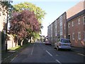
Burton Stone Lane
The grand properties on the NW side of York mostly line the main road of Bootham & Clifton. Burton Stone Lane is lined by much more modest dwellings, which at the south end are mostly mid to late 19th century and of no great architectural interest.
Image: © Gordon Hatton
Taken: 2 Mar 2012
0.05 miles
4
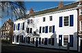
The White House, Clifton
Thomas Bowes, alderman of the city, had this house erected in 1770. Much altered over the years, so it lacks the usual symmetry of the Georgian house.
Image: © Gordon Hatton
Taken: 30 Jan 2008
0.05 miles
5
The Burton Stone Inn
On the corner of Clifton and Burton Stone Lane, the pub [built 1897] is named after the stone cross base which stands at the front of the pub. The deep shadow unfortunately masks the stone which is behind railings only a metre or so in front of the pedestrian.
Image: © Gordon Hatton
Taken: 30 Jan 2008
0.06 miles
6
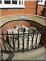
Burton Stone
Outside the public house of the same name. According to the sign behind, it is believed to be the base of a cross which formed a city boundary marker.
Image: © shirokazan
Taken: 28 Aug 2010
0.06 miles
7
Grosvenor Road - Burton Stone Lane
Image: © Betty Longbottom
Taken: 25 Sep 2010
0.07 miles
8
The White House, on the junction of St Olaves Road
Image: © Michael Jagger
Taken: 20 Feb 2010
0.07 miles
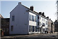
10
Victorian terrace, Clifton
Big three and a half storey terraced houses of circa 1840 on Clifton at the junction with Burton Stone Lane.
Image: © Gordon Hatton
Taken: 2 Mar 2012
0.08 miles