IMAGES TAKEN NEAR TO
Brecksfield, YORK, YO30 1YF
Introduction
This page details the photographs taken nearby to Brecksfield, YO30 1YF by members of the Geograph project.
The Geograph project started in 2005 with the aim of publishing, organising and preserving representative images for every square kilometre of Great Britain, Ireland and the Isle of Man.

There are currently over 7.5m images from over14,400 individuals and you can help contribute to the project by visiting https://www.geograph.org.uk
Image Map (Loading...)


Getting Data...Please wait
Leaflet Map data © OpenStreetMap
Images are licensed for reuse under creativecommons.org/licenses/by-sa/2.0
Notes
- Clicking on the map will re-center to the selected point.
- The higher the marker number, the further away the image location is from the centre of the postcode.
Image Listing (18 Images Found)
Images are licensed for reuse under creativecommons.org/licenses/by-sa/2.0
Image
Details
Distance


3
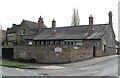
Village Hall, Skelton
The OS map of 1910 shows this as the village school. Now a community hall.
Image: © Gordon Hatton
Taken: 17 Apr 2022
0.18 miles
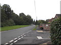
4

Moor Lane
Just off the village green in Skelton.
Image: © DS Pugh
Taken: 20 Jul 2008
0.19 miles
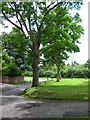
5

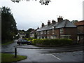
East side of Skelton
Looking through the village of Skelton on Moorlands Road.
Image: © DS Pugh
Taken: 15 Aug 2021
0.19 miles
6
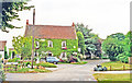
Grange Farm Guesthouse, Skelton, 1995
A pleasant and comfortable place.
Image: © Ben Brooksbank
Taken: 8 Aug 1995
0.20 miles
8
Skelton Village Green
The centre of Skelton. The church is behind.
Image: © DS Pugh
Taken: 20 Jul 2008
0.22 miles
9
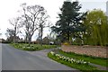
Skelton Green
Daffodils in bloom on the green.
Image: © DS Pugh
Taken: 13 Apr 2014
0.22 miles