IMAGES TAKEN NEAR TO
Beningbrough, YORK, YO30 1DD
Introduction
This page details the photographs taken nearby to YO30 1DD by members of the Geograph project.
The Geograph project started in 2005 with the aim of publishing, organising and preserving representative images for every square kilometre of Great Britain, Ireland and the Isle of Man.

There are currently over 7.5m images from over14,400 individuals and you can help contribute to the project by visiting https://www.geograph.org.uk
Image Map
Images are licensed for reuse under creativecommons.org/licenses/by-sa/2.0
Notes
- Clicking on the map will re-center to the selected point.
- The higher the marker number, the further away the image location is from the centre of the postcode.
Image Listing (172 Images Found)
Images are licensed for reuse under creativecommons.org/licenses/by-sa/2.0
Image
Details
Distance
1
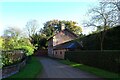
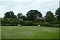
Cottage in the grounds of Beningbrough Hall
Looking towards a cottage in the estate grounds near the entrance into Beningbrough Hall.
Image: © DS Pugh
Taken: 11 Nov 2023
0.00 miles
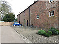
2
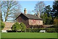
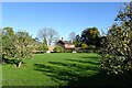
Walled garden and cottage
Part of the grounds of Beningbrough Hall.
Image: © DS Pugh
Taken: 11 Nov 2023
0.01 miles
3
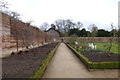
Walled gardens
Primarily a garden of produce (pears, apples and vegetables) at Beningbrough Hall.
Image: © DS Pugh
Taken: 16 Mar 2013
0.01 miles
4
Walled garden
Looking along a lavender lined border in the walled garden at Beningbrough Hall.
Image: © DS Pugh
Taken: 23 Jun 2018
0.01 miles
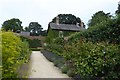
5
Towards the Garden House
Looking across the walled garden.
Image: © DS Pugh
Taken: 27 Jun 2021
0.02 miles
6
Walled garden at Beningbrough Hall
Looking across part of the walled garden in the grounds of Beningbrough Hall.
Image: © DS Pugh
Taken: 11 Nov 2023
0.02 miles
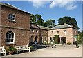
7
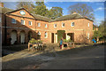
The Stable Block, Beningbrough Hall
The former stable block is now used to house the entrance and shop for visitors to Beningbrough Hall. This block is Grade II-listed (List entry Number: 1151004 https://historicengland.org.uk/listing/the-list/list-entry/1151004 Historic England).
Image: © David Dixon
Taken: 22 Oct 2017
0.03 miles
8
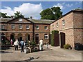
Stable Block, Beningbrough
The main block is C18; the wings, of which the eastern is shown on the right, are C19 http://www.britishlistedbuildings.co.uk/en-332103-stable-block-to-north-of-kitchen-garden- .
Image: © Derek Harper
Taken: 30 Jul 2011
0.03 miles
9
Stable Block, Beningbrough
Another view of the block shown in Image, which is where visitors to the National Trust property arrive and leave. http://www.britishlistedbuildings.co.uk/en-332103-stable-block-to-north-of-kitchen-garden- .
Image: © Derek Harper
Taken: 30 Jul 2011
0.03 miles
10
Beningbrough Hall, cycle racks
The reason for the generous provision for up to 40 bicycles (far more than at most tourist attractions) is that the Hall is close to a popular Sustrans route, and cycling out here from York is a popular summer excursion. It is also on the Way of the Roses cycle route, and I made use of this facility the following year Image
Image: © Stephen Craven
Taken: 10 Apr 2016
0.03 miles