IMAGES TAKEN NEAR TO
Tockwith Lane, YORK, YO26 7RG
Introduction
This page details the photographs taken nearby to Tockwith Lane, YO26 7RG by members of the Geograph project.
The Geograph project started in 2005 with the aim of publishing, organising and preserving representative images for every square kilometre of Great Britain, Ireland and the Isle of Man.

There are currently over 7.5m images from over14,400 individuals and you can help contribute to the project by visiting https://www.geograph.org.uk
Image Map
Images are licensed for reuse under creativecommons.org/licenses/by-sa/2.0
Notes
- Clicking on the map will re-center to the selected point.
- The higher the marker number, the further away the image location is from the centre of the postcode.
Image Listing (31 Images Found)
Images are licensed for reuse under creativecommons.org/licenses/by-sa/2.0
Image
Details
Distance
1

Horse paddock
A small jump in a horse paddock adjacent to Moor Side. In the distance can be seen the spire of Hunsingore Church.
Image: © Ian Capper
Taken: 3 May 2014
0.12 miles

3
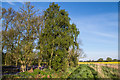
Bessy Wood
A block of woodland in an area of wide arable farming. The 1850 6 inch map shows it to have originally been named Bessy Rash, although by the time of the 1895 map it had acquired its current name.
Image: © Ian Capper
Taken: 3 May 2014
0.13 miles
4
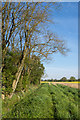
Tockwith Road
Looking towards Broad Oak Farm. Old 6 inch maps, up to and including that of 1958, show it originally to have been called Moor Lane.
Image: © Ian Capper
Taken: 3 May 2014
0.13 miles
5
Bessy Wood
A block of woodland in an area of wide arable farming, with a carpet of Bluebells contrasting with the yellow Oilseed Rape crop. Although not visible in this photo, a small group of Early Purple Orchids were growing on the bank of the ditch bordering the site.
The 1850 6 inch map shows it to have originally been named Bessy Rash, although by the time of the 1895 map it had acquired its current name.
Image: © Ian Capper
Taken: 3 May 2014
0.14 miles
6
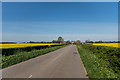
Tockwith Road approaching Broad Oaks Farm
This road goes to Cowthorpe
Image: © Martin Dawes
Taken: 9 Jul 2016
0.14 miles
7
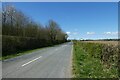
Tockwith Lane
Looking along Tockwith Lane in the direction of Cowthorpe.
Image: © DS Pugh
Taken: 5 Apr 2021
0.15 miles
8

Tockwith Road
Near Broad Oaks Farm, looking in the direction of Cowthorpe. Old 6 inch maps, up to and including that of 1958, show it originally to have been called Moor Lane.
Image: © Ian Capper
Taken: 3 May 2014
0.16 miles
9
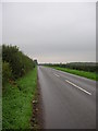
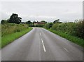
Cowthorpe to Tockwith road
Looking along the Cowthorpe to Tockwith road on a wet Monday afternoon.
Image: © DS Pugh
Taken: 25 Sep 2006
0.16 miles
10
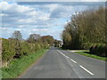
The long straight road
The Cowthorpe to Tockwith road which runs almost arrow straight for a mile.
Image: © Gordon Hatton
Taken: 5 Apr 2021
0.16 miles