IMAGES TAKEN NEAR TO
Chestnut Grove, YORK, YO26 5LE
Introduction
This page details the photographs taken nearby to Chestnut Grove, YO26 5LE by members of the Geograph project.
The Geograph project started in 2005 with the aim of publishing, organising and preserving representative images for every square kilometre of Great Britain, Ireland and the Isle of Man.

There are currently over 7.5m images from over14,400 individuals and you can help contribute to the project by visiting https://www.geograph.org.uk
Image Map
Images are licensed for reuse under creativecommons.org/licenses/by-sa/2.0
Notes
- Clicking on the map will re-center to the selected point.
- The higher the marker number, the further away the image location is from the centre of the postcode.
Image Listing (139 Images Found)
Images are licensed for reuse under creativecommons.org/licenses/by-sa/2.0
Image
Details
Distance
1
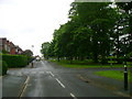
Beech Grove Acomb
A view down Beech Grove towards the shops
Image: © Sean Diver
Taken: 16 May 2007
0.05 miles
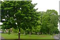
3
Acomb Green
One of the very few Greens left in York.
Image: © Martin Norman
Taken: 24 May 2005
0.07 miles
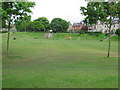
4
NER Cottage Homes
Dating from 1927 along Woodlea Avenue, Acomb.
Image: © David Rogers
Taken: 2 Feb 2010
0.08 miles
6
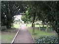
St Stephen's Graveyard - off York Road
Image: © Betty Longbottom
Taken: 6 Mar 2010
0.11 miles
7
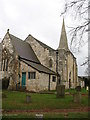
St Stephen's Church, Acomb
A rebuild of a medieval village church, with much of the present building dating from the 1830's and 1850's.
Image: © Gordon Hatton
Taken: 26 Feb 2009
0.11 miles

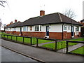
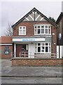
9

Acomb Office Community Services - York Road
Image: © Betty Longbottom
Taken: 6 Mar 2010
0.12 miles
10
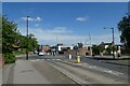
York Road roundabout
Looking across the roundabout in Acomb where York Road meets Oak Rise.
Image: © DS Pugh
Taken: 3 Jun 2022
0.12 miles