IMAGES TAKEN NEAR TO
Southfield Well Balk, DRIFFIELD, YO25 9YJ
Introduction
This page details the photographs taken nearby to Southfield Well Balk, YO25 9YJ by members of the Geograph project.
The Geograph project started in 2005 with the aim of publishing, organising and preserving representative images for every square kilometre of Great Britain, Ireland and the Isle of Man.

There are currently over 7.5m images from over14,400 individuals and you can help contribute to the project by visiting https://www.geograph.org.uk
Image Map
Images are licensed for reuse under creativecommons.org/licenses/by-sa/2.0
Notes
- Clicking on the map will re-center to the selected point.
- The higher the marker number, the further away the image location is from the centre of the postcode.
Image Listing (6 Images Found)
Images are licensed for reuse under creativecommons.org/licenses/by-sa/2.0
Image
Details
Distance
1
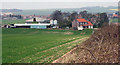
Farm and House, South of Wetwang
The buildings are located on "Southfield Well Balk", a good track running south from Wetwang Village.
Image: © Peter Church
Taken: 22 Apr 2008
0.02 miles
5
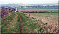
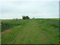
Southfield Well Balk, Wetwang
The path runs north to Wetwang which can be seen in the photograph.
Image: © Peter Church
Taken: 22 Apr 2008
0.19 miles
6
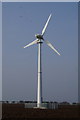
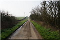
Wind turbine off Southfield Well Balk, Wetwang
Image: © Ian S
Taken: 30 Mar 2014
0.20 miles