IMAGES TAKEN NEAR TO
York Road, DRIFFIELD, YO25 9XH
Introduction
This page details the photographs taken nearby to York Road, YO25 9XH by members of the Geograph project.
The Geograph project started in 2005 with the aim of publishing, organising and preserving representative images for every square kilometre of Great Britain, Ireland and the Isle of Man.

There are currently over 7.5m images from over14,400 individuals and you can help contribute to the project by visiting https://www.geograph.org.uk
Image Map
Images are licensed for reuse under creativecommons.org/licenses/by-sa/2.0
Notes
- Clicking on the map will re-center to the selected point.
- The higher the marker number, the further away the image location is from the centre of the postcode.
Image Listing (43 Images Found)
Images are licensed for reuse under creativecommons.org/licenses/by-sa/2.0
Image
Details
Distance
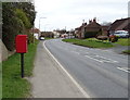
3
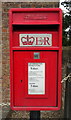
Elizabeth II postbox on Main Street, Wetwang
Image: © JThomas
Taken: 3 Apr 2020
0.03 miles
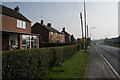
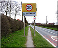
4
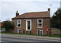
House on Main Street, Wetwang
The former Post Office.
Showing position of Postbox No. YO25 394.
See Image] for postbox.
Image: © JThomas
Taken: 3 Apr 2020
0.04 miles
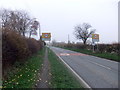
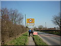
5
Main Street (A166), Wetwang
Showing position of Postbox No. YO25 394.
See Image] for postbox.
Image: © JThomas
Taken: 3 Apr 2020
0.05 miles
8
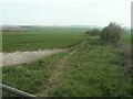
Informal field edge path, off Southfield Road
Not mapped as a public footpath.
Image: © Christine Johnstone
Taken: 20 Apr 2021
0.10 miles
9
Ridge and furrow, west of Wetwang
In a field crossed by the Chalklands Way.
Image: © Christine Johnstone
Taken: 20 Apr 2021
0.10 miles
10
Infield Fall, from Southfield Road, Wetwang
'Infield Fall' is the name given to this area in the large-scale OS map surveyed in 1850. The modern building is at Bluebell Farm.
Image: © Christine Johnstone
Taken: 20 Apr 2021
0.11 miles