IMAGES TAKEN NEAR TO
Main Street, DRIFFIELD, YO25 9XB
Introduction
This page details the photographs taken nearby to Main Street, YO25 9XB by members of the Geograph project.
The Geograph project started in 2005 with the aim of publishing, organising and preserving representative images for every square kilometre of Great Britain, Ireland and the Isle of Man.

There are currently over 7.5m images from over14,400 individuals and you can help contribute to the project by visiting https://www.geograph.org.uk
Image Map
Images are licensed for reuse under creativecommons.org/licenses/by-sa/2.0
Notes
- Clicking on the map will re-center to the selected point.
- The higher the marker number, the further away the image location is from the centre of the postcode.
Image Listing (28 Images Found)
Images are licensed for reuse under creativecommons.org/licenses/by-sa/2.0
Image
Details
Distance
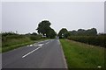
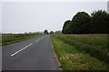
6
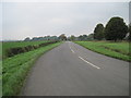
North Dalton from the East
On the B1246 approaching the village the name sign and speed restrictions can be seen.
Image: © Martin Dawes
Taken: 9 Oct 2009
0.07 miles
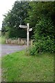
7
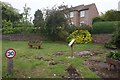
Site of the Well at East End
On main Street, North Dalton.
Image: © Ian S
Taken: 17 Jun 2020
0.08 miles