IMAGES TAKEN NEAR TO
Cranswick, DRIFFIELD, YO25 9RD
Introduction
This page details the photographs taken nearby to YO25 9RD by members of the Geograph project.
The Geograph project started in 2005 with the aim of publishing, organising and preserving representative images for every square kilometre of Great Britain, Ireland and the Isle of Man.

There are currently over 7.5m images from over14,400 individuals and you can help contribute to the project by visiting https://www.geograph.org.uk
Image Map
Images are licensed for reuse under creativecommons.org/licenses/by-sa/2.0
Notes
- Clicking on the map will re-center to the selected point.
- The higher the marker number, the further away the image location is from the centre of the postcode.
Image Listing (14 Images Found)
Images are licensed for reuse under creativecommons.org/licenses/by-sa/2.0
Image
Details
Distance


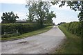
5
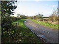
Common Farm
View west along the road to Common Farm which is near the east edge of the grid square.
Image: © Stephen Horncastle
Taken: 13 Nov 2005
0.09 miles
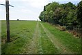
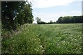
7
The Cow Holms
Now cultivated, this large field would once have been pastureland subject to seasonal flooding.
Image: © Jonathan Thacker
Taken: 23 Sep 2017
0.15 miles
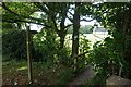
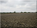
8

Cross Lane showing a very flat landscape
This runs with passing places, between Sheepman Lane and Stockbridge Lane
Image: © Martin Dawes
Taken: 10 Aug 2020
0.15 miles