IMAGES TAKEN NEAR TO
Fimber, DRIFFIELD, YO25 9LY
Introduction
This page details the photographs taken nearby to YO25 9LY by members of the Geograph project.
The Geograph project started in 2005 with the aim of publishing, organising and preserving representative images for every square kilometre of Great Britain, Ireland and the Isle of Man.

There are currently over 7.5m images from over14,400 individuals and you can help contribute to the project by visiting https://www.geograph.org.uk
Image Map
Images are licensed for reuse under creativecommons.org/licenses/by-sa/2.0
Notes
- Clicking on the map will re-center to the selected point.
- The higher the marker number, the further away the image location is from the centre of the postcode.
Image Listing (67 Images Found)
Images are licensed for reuse under creativecommons.org/licenses/by-sa/2.0
Image
Details
Distance
1

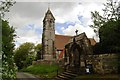
St. Mary's Church, Fimber
This shows the church of St. Mary at Fimber. Its architect was G.E. Street and construction was begun in 1858 and completed in 1871. The building is of dressed stone in the Norman style.
Image: © Dr Patty McAlpin
Taken: 2 Aug 2009
0.02 miles
2

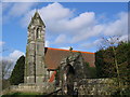
The porch and tower, Fimber church
Designed by G.E. Street 1869
Image: © Jonathan Thacker
Taken: 4 Apr 2009
0.04 miles

6

Entrance to Corner House Farm, Fimber
This shows the entrance to Corner House Farm along Burdale Lane at Fimber.
Image: © Dr Patty McAlpin
Taken: 2 Aug 2009
0.04 miles
7
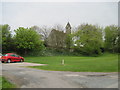
Fimber Church
St Mary's church taken from the minor road past the village pond
Image: © Martin Dawes
Taken: 5 May 2009
0.05 miles


