IMAGES TAKEN NEAR TO
Kelleythorpe Industrial Estate, Pexton Road, DRIFFIELD, YO25 9FR
Introduction
This page details the photographs taken nearby to Kelleythorpe Industrial Estate, Pexton Road, YO25 9FR by members of the Geograph project.
The Geograph project started in 2005 with the aim of publishing, organising and preserving representative images for every square kilometre of Great Britain, Ireland and the Isle of Man.

There are currently over 7.5m images from over14,400 individuals and you can help contribute to the project by visiting https://www.geograph.org.uk
Image Map
Images are licensed for reuse under creativecommons.org/licenses/by-sa/2.0
Notes
- Clicking on the map will re-center to the selected point.
- The higher the marker number, the further away the image location is from the centre of the postcode.
Image Listing (8 Images Found)
Images are licensed for reuse under creativecommons.org/licenses/by-sa/2.0
Image
Details
Distance
1
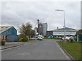
Wadsworth Road, Kellythorpe Industrial Estate
Image: © JThomas
Taken: 3 Apr 2020
0.17 miles
2
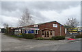
Clifton Timber
Unit on the Kellythorpe Industrial Estate.
Image: © JThomas
Taken: 3 Apr 2020
0.19 miles
3

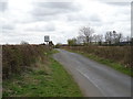
The former Driffield to Malton Railway trackbed
This scene would have looked radically different fifty years ago - roughly the time when this railway was closed.
Image: © Andy Beecroft
Taken: 25 Feb 2009
0.22 miles
4
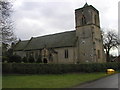
Little Driffield Church
Taken at MR: TA009965783
Image: © Andy Beecroft
Taken: 14 Feb 2006
0.22 miles
5
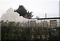
Derelict house near Little Driffield
House with no roof being demolished.
Image: © Matthew Blurton
Taken: 22 Jan 2008
0.22 miles