IMAGES TAKEN NEAR TO
Main Street, DRIFFIELD, YO25 9AL
Introduction
This page details the photographs taken nearby to Main Street, YO25 9AL by members of the Geograph project.
The Geograph project started in 2005 with the aim of publishing, organising and preserving representative images for every square kilometre of Great Britain, Ireland and the Isle of Man.

There are currently over 7.5m images from over14,400 individuals and you can help contribute to the project by visiting https://www.geograph.org.uk
Image Map
Images are licensed for reuse under creativecommons.org/licenses/by-sa/2.0
Notes
- Clicking on the map will re-center to the selected point.
- The higher the marker number, the further away the image location is from the centre of the postcode.
Image Listing (34 Images Found)
Images are licensed for reuse under creativecommons.org/licenses/by-sa/2.0
Image
Details
Distance
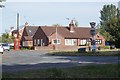
2
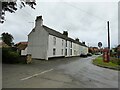
Houses on Main Street, Watton
Showing position of Postbox No. YO25 345.
See Image] for postbox.
Image: © JThomas
Taken: 31 Dec 2016
0.01 miles
3
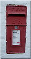
Elizabeth II postbox on Main Street, Watton
Postbox No. YO25 345.
See Image] for context.
Image: © JThomas
Taken: 31 Dec 2016
0.01 miles
6
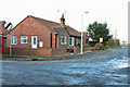
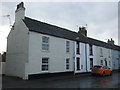
The house on the corner, Watton
As you turn into the village from Beverley Road, this is the first property that you see.
Image: © Peter Church
Taken: 12 Nov 2008
0.02 miles
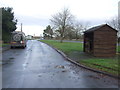
9
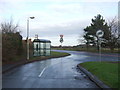
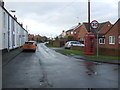
Bus stop and shelter, Watton
At the junction with Beverley Road (A164).
Image: © JThomas
Taken: 31 Dec 2016
0.05 miles
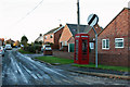
10
Watton
Looking north along the A164 which runs NS through the grid square, on the east side of Watton.
Image: © Stephen Horncastle
Taken: 14 Apr 2006
0.05 miles