IMAGES TAKEN NEAR TO
Southburn Road, DRIFFIELD, YO25 9AF
Introduction
This page details the photographs taken nearby to Southburn Road, YO25 9AF by members of the Geograph project.
The Geograph project started in 2005 with the aim of publishing, organising and preserving representative images for every square kilometre of Great Britain, Ireland and the Isle of Man.

There are currently over 7.5m images from over14,400 individuals and you can help contribute to the project by visiting https://www.geograph.org.uk
Image Map (Loading...)


Getting Data...Please wait
Leaflet Map data © OpenStreetMap
Images are licensed for reuse under creativecommons.org/licenses/by-sa/2.0
Notes
- Clicking on the map will re-center to the selected point.
- The higher the marker number, the further away the image location is from the centre of the postcode.
Image Listing (11 Images Found)
Images are licensed for reuse under creativecommons.org/licenses/by-sa/2.0
Image
Details
Distance
4
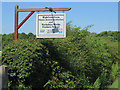
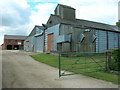
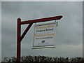
Sign at Highfield Farm, near Southburn
Outside the premises housing visitor accommodation http://highfieldfarm.co.uk/about-us and a cookery school http://yorkshirewoldscookeryschool.co.uk/
Image: © Paul Harrop
Taken: 19 Jul 2016
0.02 miles
5
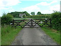
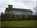
The gateway to Highfield Farm
This unpretentious building seems to be the farmhouse.
Image: © Peter Church
Taken: 20 Nov 2008
0.02 miles
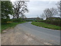
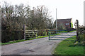
7
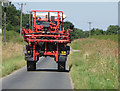
Lane near Highfield Farm
A crop sprayer squeezes along the narrow lane between Southburn and Hutton Cranswick
Image: © Paul Harrop
Taken: 19 Jul 2016
0.13 miles