IMAGES TAKEN NEAR TO
Beeford Road, DRIFFIELD, YO25 8TG
Introduction
This page details the photographs taken nearby to Beeford Road, YO25 8TG by members of the Geograph project.
The Geograph project started in 2005 with the aim of publishing, organising and preserving representative images for every square kilometre of Great Britain, Ireland and the Isle of Man.

There are currently over 7.5m images from over14,400 individuals and you can help contribute to the project by visiting https://www.geograph.org.uk
Image Map
Images are licensed for reuse under creativecommons.org/licenses/by-sa/2.0
Notes
- Clicking on the map will re-center to the selected point.
- The higher the marker number, the further away the image location is from the centre of the postcode.
Image Listing (96 Images Found)
Images are licensed for reuse under creativecommons.org/licenses/by-sa/2.0
Image
Details
Distance
1
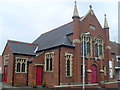
Skipsea Methodist Church (2)
This photo shows this Wesleyan Church dating from 1910 with the side entrance on the left.
Image: © David Hillas
Taken: 26 Jun 2012
0.01 miles
2

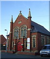
Skipsea Methodist Church (1)
Situated on the B1249 Beeford Road, this Church dates from 1910 and is one of nine Methodist Churches in the Bridlington Circuit. Services take place here at 10.30am every Sunday morning and activities are held during the week. The postcode of this Church is YO25 8TG.
Image: © David Hillas
Taken: 26 Jun 2012
0.02 miles
3

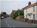
Beeford Road
Looking along Beeford Road in Skipsea.
Image: © DS Pugh
Taken: 13 Jul 2021
0.02 miles
4

The remains of farm buildings at Church Farm
Image: © Jonathan Thacker
Taken: 11 Mar 2016
0.02 miles
6
Skipsea Methodist Church
Same view four years earlier - Image
Image: © JThomas
Taken: 30 Jan 2016
0.02 miles
7

Gateway to All Saints', Skipsea
The gateway to the church is alongside the B1249, Beeford Road.
Image: © John S Turner
Taken: 6 Sep 2012
0.03 miles
8

Outbuilding at Church Farm
The only remaining farm building all the rest having been demolished. It is of typical Holderness construction - cobbles with brick patching.
Image: © Jonathan Thacker
Taken: 11 Mar 2016
0.03 miles
9
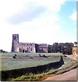
All Saints Church Skipsea
Skipsea Church taken from "little drain"
Image: © Ron Speed
Taken: Unknown
0.04 miles
10
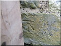
Ordnance Survey Cut Mark
This mark can be found on the wall of all Saints Church, Skipsea.
The recorded details give a height of 8.8086 metres above sea level.
For more detail see : https://www.bench-marks.org.uk/bm38541
Image: © Peter Wood
Taken: 7 Mar 2024
0.04 miles