IMAGES TAKEN NEAR TO
Plantation Drive, DRIFFIELD, YO25 8QX
Introduction
This page details the photographs taken nearby to Plantation Drive, YO25 8QX by members of the Geograph project.
The Geograph project started in 2005 with the aim of publishing, organising and preserving representative images for every square kilometre of Great Britain, Ireland and the Isle of Man.

There are currently over 7.5m images from over14,400 individuals and you can help contribute to the project by visiting https://www.geograph.org.uk
Image Map (Loading...)


Getting Data...Please wait
Leaflet Map data © OpenStreetMap
Images are licensed for reuse under creativecommons.org/licenses/by-sa/2.0
Notes
- Clicking on the map will re-center to the selected point.
- The higher the marker number, the further away the image location is from the centre of the postcode.
Image Listing (10 Images Found)
Images are licensed for reuse under creativecommons.org/licenses/by-sa/2.0
Image
Details
Distance
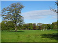
1
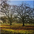
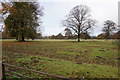
Trees near Brandesburton
Land south of the public bridleway which leads to Westfield Farm.
Image: © Paul Harrop
Taken: 18 Feb 2017
0.05 miles
2
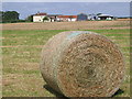
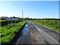
Farm near Brandesburton
Looking north in this farming grid square.
Image: © Stephen Horncastle
Taken: 20 Aug 2005
0.12 miles
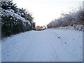
6
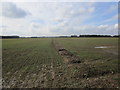
The remains of a field boundary
I would imagine that there would have been a hedge here but now all that remains is this slight ridge.
Image: © Jonathan Thacker
Taken: 9 Mar 2018
0.22 miles