IMAGES TAKEN NEAR TO
Harpham, DRIFFIELD, YO25 8JA
Introduction
This page details the photographs taken nearby to YO25 8JA by members of the Geograph project.
The Geograph project started in 2005 with the aim of publishing, organising and preserving representative images for every square kilometre of Great Britain, Ireland and the Isle of Man.

There are currently over 7.5m images from over14,400 individuals and you can help contribute to the project by visiting https://www.geograph.org.uk
Image Map
Images are licensed for reuse under creativecommons.org/licenses/by-sa/2.0
Notes
- Clicking on the map will re-center to the selected point.
- The higher the marker number, the further away the image location is from the centre of the postcode.
Image Listing (2 Images Found)
Images are licensed for reuse under creativecommons.org/licenses/by-sa/2.0
Image
Details
Distance
1
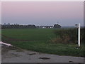
Thornholme Moor Farm
Looking east over cropland to the buildings of Thornholme Moor farm and comms tower in the fading late October sunshine.
Image: © Phil Williams
Taken: 27 Oct 2005
0.06 miles
2
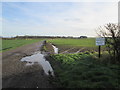
Farm road to Thornholme Moor Farm
The flat and fertile farmland of Holderness
Image: © Martin Dawes
Taken: 13 Jan 2016
0.22 miles