IMAGES TAKEN NEAR TO
Brandesburton, DRIFFIELD, YO25 8EN
Introduction
This page details the photographs taken nearby to YO25 8EN by members of the Geograph project.
The Geograph project started in 2005 with the aim of publishing, organising and preserving representative images for every square kilometre of Great Britain, Ireland and the Isle of Man.

There are currently over 7.5m images from over14,400 individuals and you can help contribute to the project by visiting https://www.geograph.org.uk
Image Map (Loading...)


Getting Data...Please wait
Leaflet Map data © OpenStreetMap
Images are licensed for reuse under creativecommons.org/licenses/by-sa/2.0
Notes
- Clicking on the map will re-center to the selected point.
- The higher the marker number, the further away the image location is from the centre of the postcode.
Image Listing (12 Images Found)
Images are licensed for reuse under creativecommons.org/licenses/by-sa/2.0
Image
Details
Distance
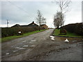
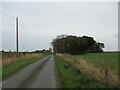
4
New Road takes a tight left
The access road to The Bungalow and Moor Cottage Farm is to the right
Image: © Martin Dawes
Taken: 14 Jun 2016
0.05 miles
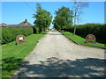
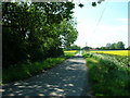
5
Walking New Road toward Moor Cottage Farm
New Road goes right after the trees and before the bungalow toward Catfoss
Image: © Martin Dawes
Taken: 3 Nov 2022
0.05 miles
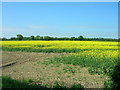
7
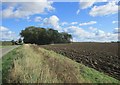
Ploughed field by New Road
Moor Cottage Road and farm are to the left of the clump of trees.
Image: © Jonathan Thacker
Taken: 5 Oct 2017
0.09 miles

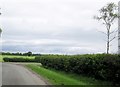
9
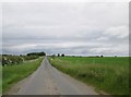
New Road over Brandesburton Moor
A minor road with passing places only for local traffic
Image: © Martin Dawes
Taken: 14 Jun 2016
0.19 miles
