IMAGES TAKEN NEAR TO
Dunnington, DRIFFIELD, YO25 8EF
Introduction
This page details the photographs taken nearby to YO25 8EF by members of the Geograph project.
The Geograph project started in 2005 with the aim of publishing, organising and preserving representative images for every square kilometre of Great Britain, Ireland and the Isle of Man.

There are currently over 7.5m images from over14,400 individuals and you can help contribute to the project by visiting https://www.geograph.org.uk
Image Map (Loading...)


Getting Data...Please wait
Leaflet Map data © OpenStreetMap
Images are licensed for reuse under creativecommons.org/licenses/by-sa/2.0
Notes
- Clicking on the map will re-center to the selected point.
- The higher the marker number, the further away the image location is from the centre of the postcode.
Image Listing (6 Images Found)
Images are licensed for reuse under creativecommons.org/licenses/by-sa/2.0
Image
Details
Distance
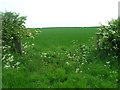
2
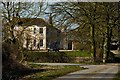
Towards Dunnington Grange
Looking west along the lane towards Dunnington Grange (the house on the left of the picture).
Image: © Paul Harrop
Taken: 11 Mar 2015
0.04 miles
6

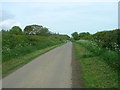
Track South Of Upton
A typical view of this grid square which is all farmland.
Image: © Stephen Horncastle
Taken: 2 Feb 2007
0.25 miles