IMAGES TAKEN NEAR TO
Water Lane, DRIFFIELD, YO25 8DZ
Introduction
This page details the photographs taken nearby to Water Lane, YO25 8DZ by members of the Geograph project.
The Geograph project started in 2005 with the aim of publishing, organising and preserving representative images for every square kilometre of Great Britain, Ireland and the Isle of Man.

There are currently over 7.5m images from over14,400 individuals and you can help contribute to the project by visiting https://www.geograph.org.uk
Image Map
Images are licensed for reuse under creativecommons.org/licenses/by-sa/2.0
Notes
- Clicking on the map will re-center to the selected point.
- The higher the marker number, the further away the image location is from the centre of the postcode.
Image Listing (65 Images Found)
Images are licensed for reuse under creativecommons.org/licenses/by-sa/2.0
Image
Details
Distance
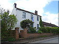
2
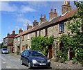
Far Lane, Bewholme
Cottages on the north side of the cul-de-sac
Image: © Paul Harrop
Taken: 19 Jul 2008
0.08 miles
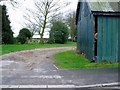
3
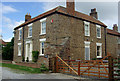
Laburnum Farm, Bewholme
At the end of Far Lane
Image: © Paul Harrop
Taken: 19 Jul 2008
0.08 miles
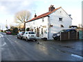
4
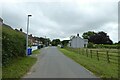
Skipsea Road
Looking along Skipsea Road through Bewholme.
Image: © DS Pugh
Taken: 13 Jul 2021
0.08 miles
5
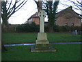
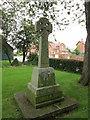
War Memorial, Church of St John the Baptist, Bewholme
Image: © JThomas
Taken: 6 Jan 2018
0.13 miles
10
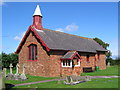
St, John the Baptist, Bewholme
Bewholme is in this and the adjacent square south. The church is on the south edge of the square. The whole of the surrounding area is farmland.
Image: © Stephen Horncastle
Taken: 20 Aug 2005
0.13 miles