IMAGES TAKEN NEAR TO
Mill View Crescent, DRIFFIELD, YO25 8DS
Introduction
This page details the photographs taken nearby to Mill View Crescent, YO25 8DS by members of the Geograph project.
The Geograph project started in 2005 with the aim of publishing, organising and preserving representative images for every square kilometre of Great Britain, Ireland and the Isle of Man.

There are currently over 7.5m images from over14,400 individuals and you can help contribute to the project by visiting https://www.geograph.org.uk
Image Map
Images are licensed for reuse under creativecommons.org/licenses/by-sa/2.0
Notes
- Clicking on the map will re-center to the selected point.
- The higher the marker number, the further away the image location is from the centre of the postcode.
Image Listing (24 Images Found)
Images are licensed for reuse under creativecommons.org/licenses/by-sa/2.0
Image
Details
Distance
1
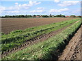
Beeford Footpath
This grid square is just about all farmland. This view looking NW from the path which heads of east into the adjacent square to the A165.
Image: © Stephen Horncastle
Taken: 26 Sep 2006
0.07 miles

5
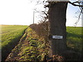
Why private?
Do not be put off by the notice. A public right of way goes from here and crosses the field to the left. The farmer has ploughed up the path so he cannot blame any walker who does not stick to the path.
Image: © Ian S
Taken: 2 Jan 2012
0.11 miles
6
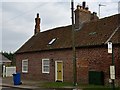
Cottage on Main Street, Beeford
Part of Alton Farm on the south side of the village. Note the 'spiral' chimney stack on the left.
Image: © Paul Harrop
Taken: 20 Mar 2015
0.11 miles
7
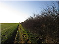
Farmland to the south of Beeford
There is a footpath across this field to the left, but the farmer as ploughed it up.
Image: © Ian S
Taken: 2 Jan 2012
0.13 miles
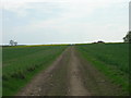
8
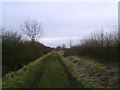
Track into Village
The footpath across the fields from Gembling becomes a green track as it nears Beeford.
Image: © Martin Dawes
Taken: 3 Mar 2009
0.14 miles
9
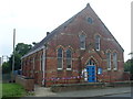
Beeford Methodist Church (2)
This photo shows the Wesleyan Church with its Union Jack flags dangling from the front rail. Methodist Churches dating from the 19th Century tended to be built like the one pictured here with its door at the front and its windows at the front and side. An electricity power supply post can be seen in the distance on the left of the photo.
Image: © David Hillas
Taken: 26 Jun 2012
0.14 miles
10

Beeford Methodist Church (1)
Situated on the B1249 Main Street, this Church dates from 1866 and is one of thirteen churches in the Driffield Methodist Circuit. Services take place here every Sunday at 10.30am and activities are held during the week. Its postcode is YO25 8AY.
Image: © David Hillas
Taken: 26 Jun 2012
0.14 miles